High-Voltage Power Transmission Lines Drone Inspections

Drone Harmony’s Power Scanner is a data acquisition software platform dedicated to capturing power pole and high-voltage transmission lines drone data at scale. It provides a fully integrated toolset for planners and field operators to plan, coordinate, and execute safe drone flights to gather data around power infrastructure. Above all, it was designed with data analytics in mind, providing unparalleled customization and integration capabilities.

Schedule a Demo

Efficient and Reliable Digitalization of Powerlines

Enhancing Power Utilities Inspections

Power Scanner is a data acquisition tool designed to achieve standardized and efficient data collection. It offers centralized control for managing flight patterns, data resolution, and capture methodologies, ensuring uniform data collection across all field crews. Power Scanner streamlines data acquisition, eliminating inconsistencies and discrepancies in the information gathered. Its auto-referencing feature connects data to physical assets, making it easier to organize and analyze, preventing disorganized data and enhancing the overall efficiency of digital inspection processes.

Contact Us

Efficient and Customizable Mission Planning

Plan your flights with confidence in a visual Full-3D interface that guides you through every step of the process. Power Scanner generates ready-to-fly missions optimized for your specific types of powerlines, masts, and transmission towers.

From app launch to drone takeoff in 2 minutes

The Power Scanner mobile app is designed to maximize safety and productivity in every scenario. Its simple three-step workflow is as easy as choosing the assets to inspect on the map (poles, lines), choosing the inspection type and tapping Launch. At the same time, for those complex cases where the standard workflow does not cut it, Power Scanner provides all the flexibility needed to make any required adjustments in the field: load projects, add obstacles, adjust flight parameters, tweak data quality requirements and more.

Achieving unprecedented detail in your images

Power Scanner’s flight app calibrates automatically to achieve maximal flight accuracy, resulting in sharper, more detailed image data than any drone inspection software. Power Scanner takes full control of the drone and the payload, ensuring perfect positioning, camera angle, centering, focus, shutter, and light for every image.

Use Your Preferred Hardware and Software

Drone Harmony supports all professional DJI drones and custom payloads, including the highly advanced Phase One P3. Moreover, it is designed to integrate seamlessly with DJI smart controllers and is available across multiple platforms. This allows users to access its powerful features no matter their preferred device. But that's not all - our software also integrates seamlessly with leading software solutions for fault detection, photogrammetry, annotation, and reporting. Take full advantage of all the advanced features that Drone Harmony offers while leveraging the power of other industry-leading solutions.

Schedule a Demo

Skip the manual climbing or flying - Work with Drone Harmony instead. Your benefits:

Save Time On Site

Automated flight planning and execution. Intuitive and streamlined workflow. Flight planning includes environment aware obstacle avoidance.

Get High Quality Data

Full coverage and accurate images of electric utilities, roads, or pipelines are guaranteed by optimization algorithms.

Reduce Cost

Perform more inspections with less skilled personnel. High data quality reduces image processing costs.

Scalable Solution

Flight plans can be shared and repeatedly flown. Train beginner pilots in less than 30 minutes.

Full 3D Work Environment

Plan and visualize both asset and flight plan in 3D for accurate and predictable results.

Latest news about power lines and linear inspections

Unveiling the Drone Harmony Image Gallery, UI Improvements, Floating Obstacles, and Speed Control Features

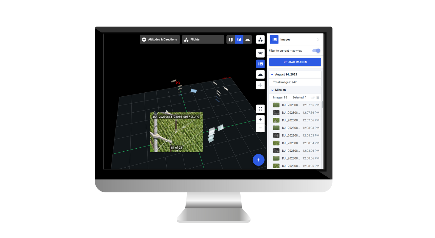
This blog post will explore the latest Drone Harmony enhancements, including the brand-new image gallery feature! Additional features include user interface improvements for large missions, floating obstacles, the ability to set speed on waypoints, and enhanced speed visualization. Let’s dive in and discover how these features can enhance your drone missions. Image Gallery: Unleash the...

Continue reading

Drone Harmony Now Supports the Entire DJI Enterprise Drone Lineup!

Drone Harmony has released a new update for its professional drone mission planning software for commercial use. The software now supports all new DJI Enterprise drones, including Mavic 3 Enterprise Thermal, Matrice 30 Thermal, and Matrice 300 RTK. The highlight of the recent release is the new support of the DJI’s Matrice 30 and Mavic...

Continue reading

Drone Harmony Power Scanner: Advancing Power Utility Line Inspection

Drone technology is transforming the power utilities industry, enabling more efficient and cost-effective operations for inspecting and maintaining critical infrastructure. One platform that is leading the charge in this space is Drone Harmony Power Scanner, which offers a suite of advanced features designed specifically for line inspection. At the heart of the platform is a...

Continue reading

Partners

Become a partner Learn more

Industries

Business intelligence derived from drone data is only as good as the data that is used to generate it.