Globally ~93.5$ trillions in infrastructure investment is required by 2040 to sustain global growth predictions. At the same time, there are millions of existing assets which require inspection and monitoring to ensure their safety and longevity.
Alarming numbers
The concrete Morandi bridge in Genova that collapsed in August 2018 (killing 43 people and leaving 600+ people homeless) was not maintained sufficiently. Most of the 600,000+ bridges in the US already exceeded their lifetime. Annual costs of inspection of a typical bridge are ~10,000 Dollars, resulting in up to 6 billions Dollars annual costs.
The assets lack digitization
The challenge of ageing infrastructure can be be addressed with the opportunity presented by digital workflows. Digitization affects all stages of an asset’s lifecycle – from construction to maintenance. It enables significant operational cost reductions through new timely insights into the asset state. Digitization also enables the automation of many tasks related to maintenance and fault detection that until today were not carried out at the necessary frequency, due to the required manual labor. Despite the positive trend of digital workflows, however, for the most part, the data currently available to infrastructure operators is not sufficient for analytics. It is often outdated, incomplete, false or inaccessible. As a result, today infrastructure is one of the least digitized sectors in the global economy. With the aid of the commercial drone market this problem can now be resolved.
Drone Harmony automates high quality data collection at scale
Drone Harmony enables large enterprises to go digital at scale by automating the data collection with drones. Drone Harmony’s software as a service platform automates the flight planning and execution for industrial off the shelf drones, thereby turning anyone into a professional drone pilot and scaling up drone operations. Mathematically optimized and repeatable flight paths guarantee the desired data quality and consistency.
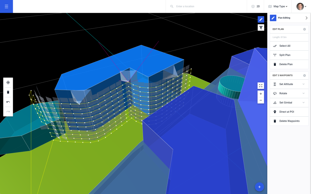
Drone Harmony mission planning based 3D model of a church
Drone Harmony strategically works with selected large enterprises to align the data acquisition platform with existing processes inside target markets, thereby accelerating the adoption of drones-based digitization technologies.
Drone Harmony’s 3D data capture platform consists of mobile and web applications and a cloud service, all fully integrated. It is designed for easy incorporation into the enterprises’ infrastructure workflow and supports off-the-shelf, widely available drones, making it globally deployable. The key enabling technology is an automated mission planning capability that exploits GIS, CAD and shapes data about the geometry of the inspected asset and its environment to generate and execute safe and optimized data capture missions in complex use cases. Drone Harmony’s platform is the first to incorporatea full 3D working interface.
Full 3D working interface
Automation is key for scale
The logic is simple. Digital workflows can only bring value to an enterprise if they can be realistically applied on thousands of assets in a reliable and reproducible way. Such level of reliability can only be obtained through automation of all associated processes: from data capture to analytics. To automate data capture one needs a software system that can understand the geometric complexity and subtleties of the inspected objects, the environment the overall goals of the mission. A system like that should be based on consuming geometric and semantic 3D data for generating and executing flight missions. At Drone Harmony, we are doing just that.
Legislative Update On June 18, 2024, the House of Representatives passed the National Defense Authorization Act (NDAA), which includes the “Countering CCP Drones Act.” This bill aims to ban DJI drones by prohibiting their use of FCC communication infrastructure. However, the Senate Armed Services Committee (SASC) has recently released its marked-up version of the 2025...
We’re thrilled to announce a major update that combines all versions of our app into one streamlined platform, providing enhanced convenience and efficiency for both enterprise and professional users. Consolidation of Versions With this update, we have merged all versions of the app into a single comprehensive platform. This consolidation includes: Improved Accessibility Upon opening...
We are thrilled to announce a significant addition to our team. Adam Saciuk, with over twenty years of pioneering experience in industrial operational optimization, inspection, and drone program design, implementation, and execution, has joined Drone Harmony as the Chief Operations Officer for North America. This exciting development marks a pivotal moment in Drone Harmony’s journey...
March 2, 2024
Copyright 2024 Drone Harmony AG. All Rights Reserved.