Major Update: Consolidating Versions for Enhanced Efficiency
April 16, 2024
We’re thrilled to announce a major update that combines all versions of our app into one streamlined platform, providing enhanced convenience and efficiency for both enterprise and professional users.
Consolidation of Versions
With this update, we have merged all versions of the app into a single comprehensive platform. This consolidation includes:
Power Scanner Distribution and Power Scanner Transmission: Users can now access both versions of Power Scanner seamlessly within the app.
Tower Scanner: Tower Scanner functionality is now integrated into the unified platform, simplifying workflows for cell tower inspection tasks.
General Mapping and Terrain app: The mapping and terrain capabilities are now part of the consolidated app, allowing users to perform various mapping and inspection tasks efficiently.
Improved Accessibility
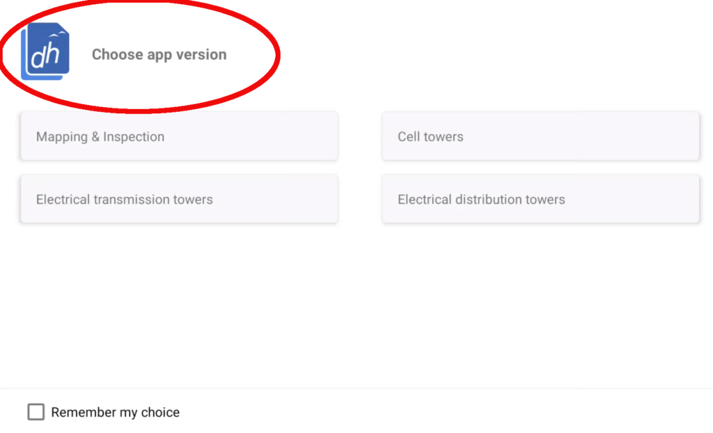
Upon opening the app, users will now have the option to select the specific version they wish to use, tailored to their requirements and preferences. This flexibility ensures that users can access the features most relevant to their projects with ease.
Access Levels
Depending on the user’s subscription plan, access to certain features may vary:
Enterprise: Users with enterprise-level subscriptions will have access to all features within the app, empowering them to leverage the full range of capabilities for their operations.
Professional: Professional users will have access to the Mapping and Terrain features without the need to select from a menu, streamlining their experience for focused tasks.
Customization Options
To further enhance user experience, we have introduced customization options:
Default Version Selection: Users can choose a default version of the app based on their frequently performed tasks or preferences.
Changeable Settings: The option to change the default version can be found within the Settings menu, providing users with the flexibility to adjust their preferences as needed.
In addition, Drone Harmony’s recent updates bring significant enhancements, including bug fixes for smoother map navigation and tower color customization for improved visual organization. Additionally, integration of the Sony a7R IV camera expands compatibility, while streamlined mission handling and camera control enhancements enhance the overall user experience.
Stay tuned for more updates as we continue to innovate and enhance our offerings to meet the evolving needs of the drone industry.
Legislative Update On June 18, 2024, the House of Representatives passed the National Defense Authorization Act (NDAA), which includes the “Countering CCP Drones Act.” This bill aims to ban DJI drones by prohibiting their use of FCC communication infrastructure. However, the Senate Armed Services Committee (SASC) has recently released its marked-up version of the 2025...
We are thrilled to announce a significant addition to our team. Adam Saciuk, with over twenty years of pioneering experience in industrial operational optimization, inspection, and drone program design, implementation, and execution, has joined Drone Harmony as the Chief Operations Officer for North America. This exciting development marks a pivotal moment in Drone Harmony’s journey...
We are excited to support our fast-growing customer base and partner ecosystem and are gearing up to support more industries than ever before in 2024! As ultra-flexible hardware platforms like DJI Dock hit the market, all heavy industries take notice and commence proofs of concept. Drone Harmony provides maximum flexibility and control in one platform...
January 10, 2024
Copyright 2024 Drone Harmony AG. All Rights Reserved.