Enhancing Your Drone Data Analysis with The New Image Panel
October 3, 2023
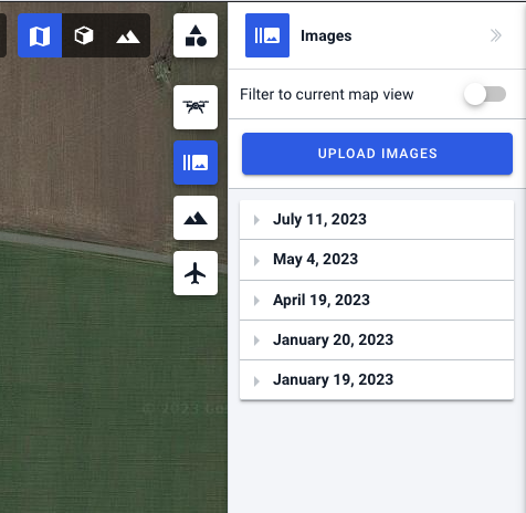
We’re excited to announce a powerful new feature that will revolutionize your drone data analysis experience. Our web app just got a major upgrade with the introduction of the “Images” panel, located conveniently on the right side of the interface. This feature is designed to streamline the processing and visualization of DJI drone-made images, providing you with valuable insights from your aerial data.
The Power of DJI Image Integration
With the new images upload, users can seamlessly upload and process images captured using DJI drones.
Extracting Exif Metadata
One of the standout features of this enhancement is the extraction of Exif metadata from your images. Exif metadata includes crucial information such as the location of the photo, camera exposure settings, and much more.
High-Quality Thumbnails
In addition to extracting metadata, our system automatically generates high-quality thumbnails. These thumbnails provide a quick and convenient way to preview your images without the need to open each one individually. This feature makes image navigation a breeze.
Efficient Image Organization
If you have corresponding log files for your drone missions, our system takes it a step further by intelligently grouping your images into folders according to the mission name. This organizational structure simplifies the management of large datasets, saving you time and effort.
Interactive Map and 3D View
The magic of this feature doesn’t stop at data processing. We’ve integrated a dynamic visualization component that displays your images on both a map and a 3D view, allowing you to explore your data in a whole new way. You can now see exactly where each image was taken, providing context and spatial understanding.
User-Friendly Image Management
Our goal is to make your workflow as seamless as possible. In the images panel, you have the ability to download images, view them, and explore their metadata. This level of control ensures that you can quickly access the information you need and make informed decisions based on your aerial data.
Try out our new images panel today and experience the future of drone data analysis. Your data has never been more accessible, informative, and visually engaging. Happy flying!
Legislative Update On June 18, 2024, the House of Representatives passed the National Defense Authorization Act (NDAA), which included the “Countering CCP Drones Act” aimed at banning DJI drones. Recently, the Senate Armed Services Committee (SASC) released its version of the NDAA without these provisions. However, two US Senators have now introduced an amendment to...
We’re thrilled to announce a major update that combines all versions of our app into one streamlined platform, providing enhanced convenience and efficiency for both enterprise and professional users. Consolidation of Versions With this update, we have merged all versions of the app into a single comprehensive platform. This consolidation includes: Improved Accessibility Upon opening...
We are thrilled to announce a significant addition to our team. Adam Saciuk, with over twenty years of pioneering experience in industrial operational optimization, inspection, and drone program design, implementation, and execution, has joined Drone Harmony as the Chief Operations Officer for North America. This exciting development marks a pivotal moment in Drone Harmony’s journey...
March 2, 2024
Copyright 2024 Drone Harmony AG. All Rights Reserved.