Drone Harmony Basic vs. Drone Harmony Plus: What’s included.
July 20, 2018
Drone Harmony’s recent professional release sees two products hit the market: Drone Harmony Basic and Drone Harmony Plus. This article describes the differences in features and functionality between the two apps.
Which Drone Harmony app is right for me? In our recent article Choosing the Drone Harmony plan that’s right for your business we’ve described how different businesses can benefit from different license plans for Drone Harmony Plus, Drone Harmony’s industrial grade mobile application. We focused on business size and the type of DJI drones that can be used with each plan. In this article we focus on features, namely on what you can do with Drone Harmony Basic, and what you will need Drone Harmony Plus for.
What’s Included in them all
Drone Harmony’s mission planners are unique in that they are based on a scene-centered workflow, they feature a full 3D working environment and that they generate plans automatically that avoid obstacles in the scene. All of these aspects are present in all of Drone Harmony applications.
In addition, both Drone Harmony Basic and Drone Harmony Plus include all of the following missions in the Plan Catalog.
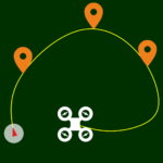
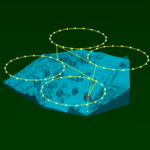
Shapes. These missions include Orbit, Helix, several reveal shots, Flatland etc. and are great for capturing cinematic photos and stunning videos.
Quick. These shots are great for making beautiful selfie-like spontaneous shots.
Manual. These missions let you plan out waypoint missions by either placing waypoints, or by flying the drone and recording its position.
Other important features present in all Drone Harmony application include points of interest (POIs), flight smoothing, Airdata integration and much more.
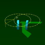
Record POIs
Rocket
Flatland
Finally, Drone Harmony application includes a unique Calibration Position mission that can be used to adjust the positions of the scene objects and thus eliminate inaccuracies caused by outlining objects on a map.
Drone Harmony Basic – beautiful cinematography and easy mapping
Drone Harmony Basic is your perfect companion for everything related to cinematic photography/videography and mapping. It is the perfect app for anyone who wants to take breathtaking photos and videos with their DJI Mavic or Phantom series drone. It includes an abundance of cinematic flights patterns that are fully and easily customizable, plan smoothing for slick videos and much more.
In addition, Drone Harmony Basic is a versatile mapping tool capable of easily gathering data for 2- and 3D mapping. It includes:
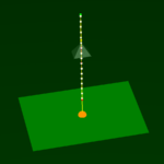
The Top Down mission, suited for capturing nadir shots of any collection of scene objects (e.g. roofs, fields etc.). This mission is perfect for inspections and 2D mapping (orthomosaics). To learn more about the Top-Down mission see Top Down Scans: An Introduction and an Advanced Use Case
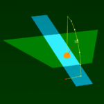
The Site mission, perfect for collecting a comprehensive image set of a complex 3D structure, such as a building or tower. This flexible mission is suited for anything from inspection to high resolution 3D mapping of complex structures.
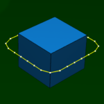
The Perimeter, Circle, Ellipse and Convex Hull missions, tailored for capturing oblique pictures and videos of 3D structures. See our blog post Smart missions for everyone for a comparison between these missions.
Top-Down
Site
Perimeter
With the exception of Drone Harmony Plus, this feature set makes Drone Harmony Basic the most powerful mission planner on the market. Have a look at the license plans to see which types of DJI drones can be used with Drone Harmony Basic.
Drone Harmony Plus – the ultimate data capture tool for drone professionals
Drone Harmony is available in a number of licensing plans. Drone Harmony Plus is the most versatile and powerful drone data collection tool on the market. It is perfect for drone professionals, regularly carrying out diverse mapping and inspection missions. Drone Harmony Plus includes all the functionality of Drone Harmony Basic and adds on top of that several market first advanced mapping and inspection capabilities.
Additional advanced mapping capabilities include:
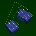
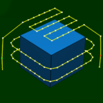
The Mapping Orbits mission that can be used to cover any number of regions in the scene with orbits and collect oblique images with a user defined angle for accurate 3D reconstruction of complex 3D environments.
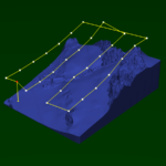
Terrain Aware planning allows the user to import point clouds that represent an elevation (terrain) map and plan mapping missions that represent the terrain. See this page for information on how to work with terrain.Two missions can be used to plan with terrain data: Terrain Top Down and Terrain Orbits, which are analogues of Top Down and Mapping Orbits, except that they can be used to keep constant altitude above an imported terrain model.
Mapping Orbits
Terrain Top-Down
Terrain Orbits
Additional inspection capabilities include:
The Facade Modeling mission enables accurate yet easy mapping of facades of buildings and other vertical structures.
Facade Inspection
Finally, Drone Harmony Plus includes Cell Tower Inspection, the first application on the market that tailored for the sole purpose of cell tower inspection, as an additional skin. Cell Tower Scan includes a total nine additional missions for capturing perfect data for both visual inspection and 3D reconstruction. See “How does DH solve the Cell Tower Inspection Pilot’s Problems?” and “DH’s New Tower Scan App” for a detailed introduction to Cell Tower Scan.
Tower Inspection
Have a look at the license plans to see which types of DJI drones can be used with Drone Harmony Plus. You will also find an overview of all features and functionalities here.
The Best Way to Decide
If you are still unsure what product is right for you, there is simple way to help yo make the decision: try them out for free and see what value you get from each one.
Legislative Update On June 18, 2024, the House of Representatives passed the National Defense Authorization Act (NDAA), which includes the “Countering CCP Drones Act.” This bill aims to ban DJI drones by prohibiting their use of FCC communication infrastructure. However, the Senate Armed Services Committee (SASC) has recently released its marked-up version of the 2025...
We’re thrilled to announce a major update that combines all versions of our app into one streamlined platform, providing enhanced convenience and efficiency for both enterprise and professional users. Consolidation of Versions With this update, we have merged all versions of the app into a single comprehensive platform. This consolidation includes: Improved Accessibility Upon opening...
We are thrilled to announce a significant addition to our team. Adam Saciuk, with over twenty years of pioneering experience in industrial operational optimization, inspection, and drone program design, implementation, and execution, has joined Drone Harmony as the Chief Operations Officer for North America. This exciting development marks a pivotal moment in Drone Harmony’s journey...
March 2, 2024
Copyright 2024 Drone Harmony AG. All Rights Reserved.