Unlocking the Power of Point Clouds in Drone Harmony
April 3, 2024
In the realm of drone mission planning, the utilization of point clouds marks a significant leap forward, offering a multitude of advantages over conventional 2D or 3D methodologies. Let’s delve into how incorporating point clouds into your drone operations will revolutionize your workflow.
Advantages of Point Cloud-Based Planning
When it comes to enterprise flight operations, achieving a larger degree of control, safety, and efficiency can mean the difference between sustainably scaling drone programs and never breaking past the PoC stage. There are many aspects of flight management software that contribute to that. In this section, we explore how the FULL-3D point cloud-based planning adds enormous value on all fronts.
Efficiency: One of the standout benefits of leveraging point clouds is the remarkable efficiency they bring to mission planning. With crucial data such as building heights and obstacle dimensions readily available, the planning process is expedited, eliminating the need for time-consuming reconnaissance.
Safety: Enhanced accuracy and comprehensive scene understanding afforded by point clouds translate into heightened safety during flight operations. Pilots gain precise control over their surroundings, significantly reducing the risk of accidents or collisions.
Data Quality: The meticulous placement of points of interest (POIs) and thorough inspection within the point cloud environment yield unparalleled data quality. Thanks to precise georeferencing and refined planning capabilities, data acquisition is optimized, capturing desired angles and details with remarkable precision.
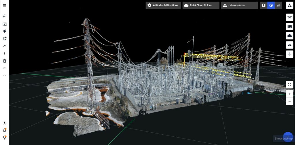
Decoupling Planning Expertise from Piloting: By entrusting less experienced pilots with flights executed according to meticulously planned trajectories, organizations can maintain consistency in data quality without relying solely on seasoned specialists. This decoupling streamlines operations and reduces costs associated with highly skilled manpower. For example, by carefully pre-planning a utility substation inspection in Drone Harmony based on a LiDAR scan of the site, a subject matter expert can task any drone pilot in the geographic vicinity of the asset to execute the flights.
Continuous advancement: As Drone Harmony continues to push the boundaries of innovation, users can anticipate many upcoming features designed to enhance their experience further. Among these enhancements is the ability to delineate sloping roofs on buildings, providing even greater versatility and accuracy in mission planning.
Point Cloud Workflow in Drone Harmony
Accessing Point Cloud Files
The availability of point cloud data varies significantly by region. In places like Bavaria, comprehensive datasets are freely accessible for download, facilitating seamless integration into Drone Harmony workflows.
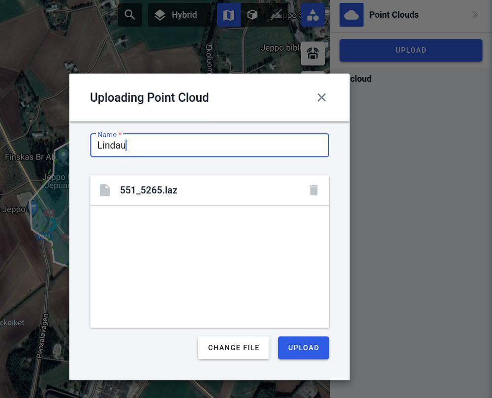
Upload to Drone Harmony
You can upload your point cloud file (a .las or .laz file) into Drone Harmony in just a few steps. The new point cloud panel in the right-hand side menu can be used (while in Map view). Already uploaded point clouds will be listed there as well. Press the Upload button, drag and drop the point cloud file(s) to upload, and provide the EPSG code of their coordinate system. After a few minutes, your point clouds should be ready to use.
Point clouds are useful to easily define areas of interest and plan missions with an intuitive point-and-click workflow within the point cloud’s visual context.
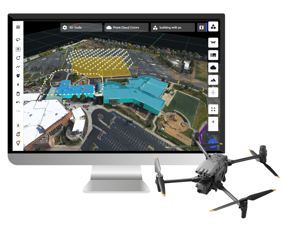
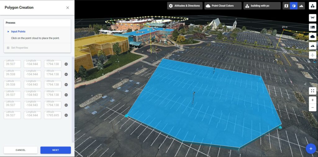
Using a point cloud to outline objects in 3D
Once uploaded, point clouds automatically appear in Drone Harmony’s 3D view in the web app. The user can then use several 3D tools from the left-hand menu to outline polygonal regions, lines, points of interest, and composite structures (such as utility masts) by simply clicking on points in the point cloud.
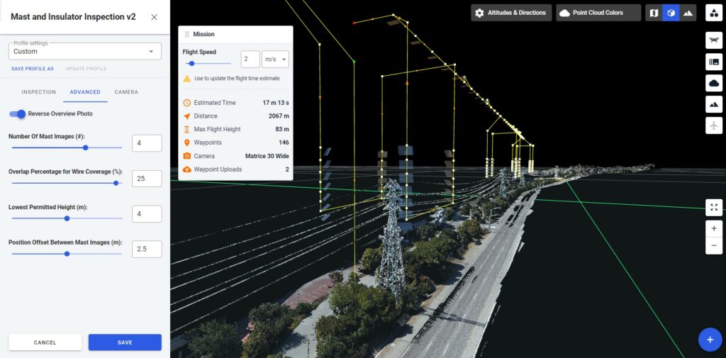
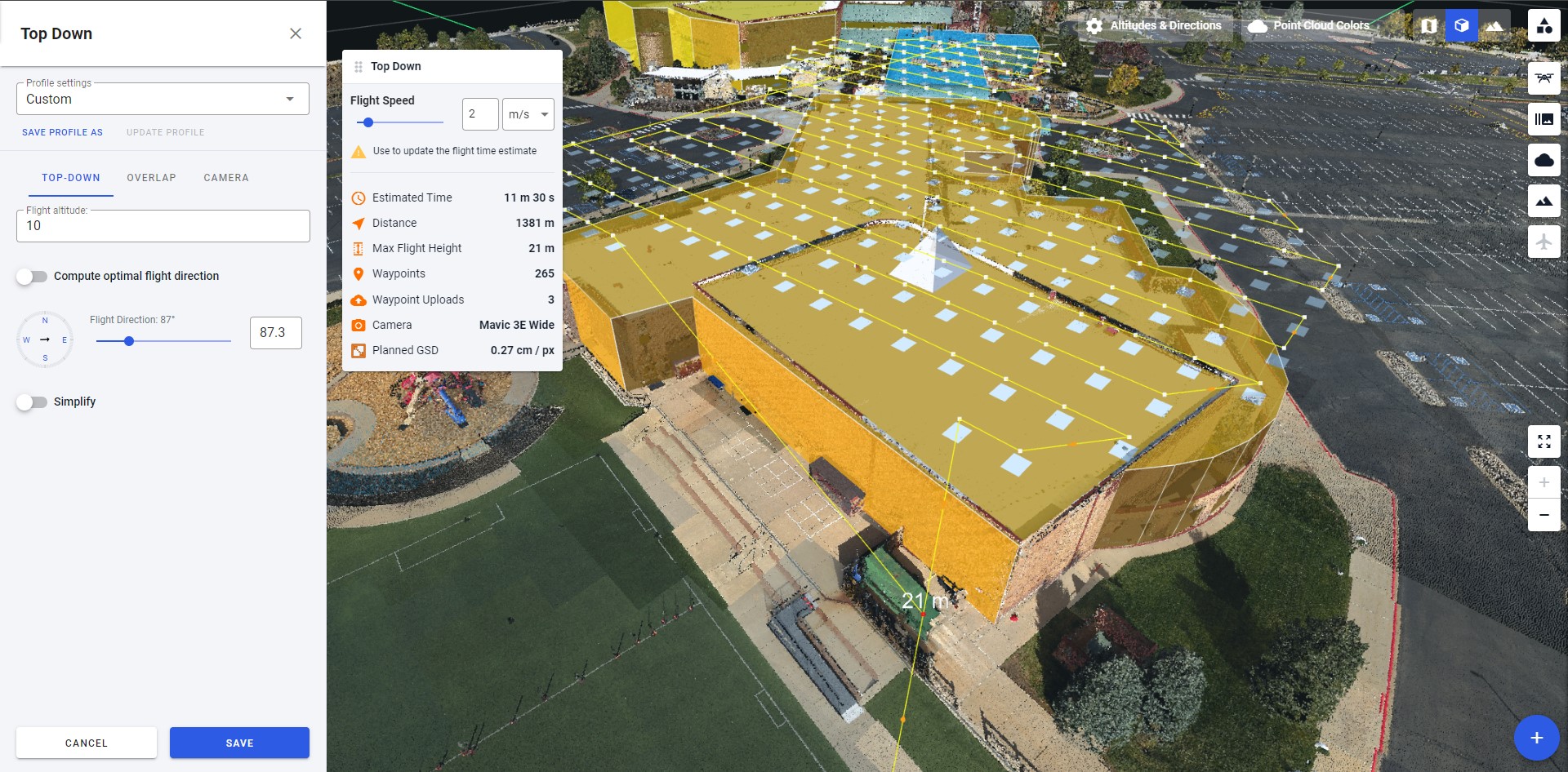
Planning flights with point clouds
With areas of interest outlined in the point cloud view, any automated flight mission can be generated with the standard Drone Harmony workflow. For example, a complex building can be easily outlined by clicking on its perimeter corner points in the point cloud, and a mission to inspect the roof of the building can easily be created:
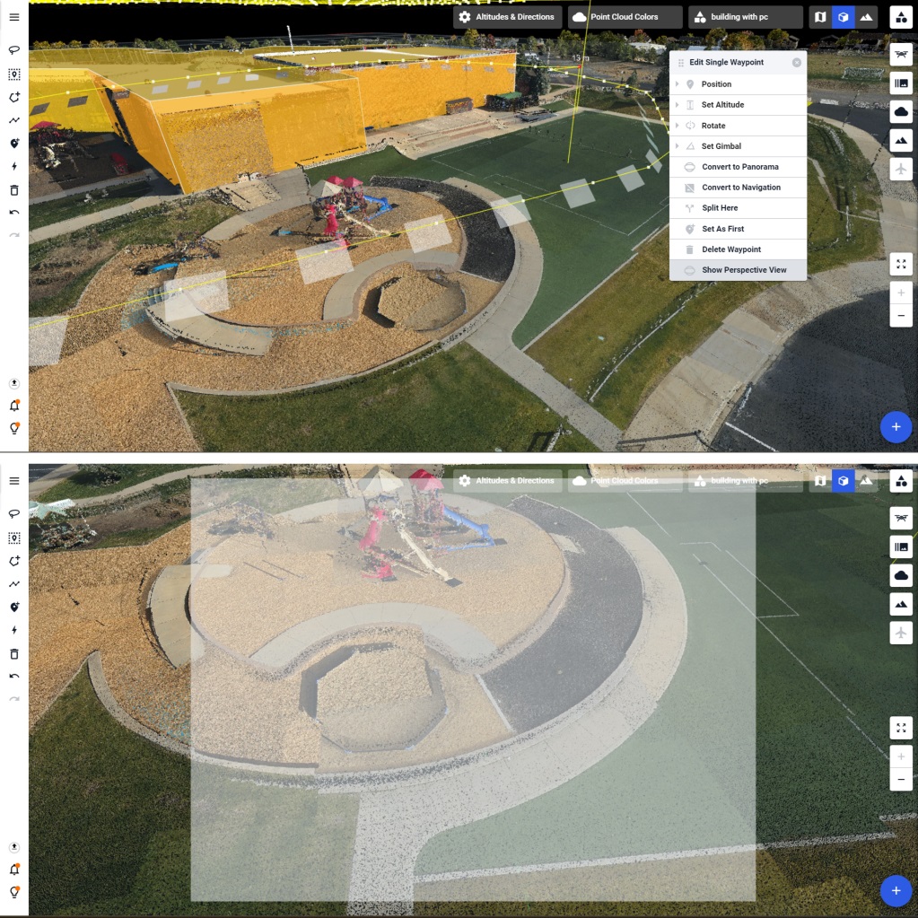
Adjusting parts of missions is also easy and intuitive within the point cloud view. Waypoints can be outlined with a lasso tool and deleted, or height-adjusted to void a visible obstacle. You can even view the scene through a waypoint in the planned mission to see the content of each planned image before you leave the office:
In conclusion, the integration of point clouds into Drone Harmony represents a paradigm shift in drone mission planning, unlocking unprecedented control, efficiency, safety, and data quality. With ongoing advancements and a commitment to innovation, Drone Harmony continues to empower users with cutting-edge capabilities, propelling the field of aerial data acquisition into a new era of possibility.
Here we are! The big release of DJI Enterprise Drones App v2.5.0 (by August 2023) We are excited to introduce the latest major mobile release for DJI Enterprise Drones, version 2.5.0! What`s the point? For a couple of months, we have learned a lot from our customer’s feedback and experience while getting ready for this important...
Drone Harmony is a software solution designed specifically for drone inspection missions. In this blog post, we will outline the steps involved in performing inspections using Drone Harmony. Drone technology has transformed the way inspections are carried out across various industries. With the ability to capture high-resolution images and video, drones are becoming increasingly popular...
We are happy to announce the new version of our Android application! Better user experience, more features and simpler setup are only part of the included improvements. Drone Harmony is pleased to announce the release of a brand new version of Drone Harmony Mobile for Android. The new app is based on our learnings and...
April 25, 2022
Copyright 2024 Drone Harmony AG. All Rights Reserved.