How A Professor teaches His Students Photogrammetry in a Visual and Interactive Way
Stephan Nebiker, Professor of photogrammetry, remote sensing, and geoinformatics at the Institute of Geomatics Engineering of FHNW, uses Drone Harmony in bachelor and master photogrammetry classes. He teaches students the processes of digital aerial photogrammetry. We were invited to talk with him.
Stephan, please introduce yourself.
I am a photogrammetry, remote sensing, and geoinformatics professor at the Institute of Geomatics Engineering of FHNW, focusing on teaching and researching 3D imaging, mobile mapping, and UAV-based photogrammetry and remote sensing.
How are drones employed in the field of geomatics?
Combining a drone with a camera or a LiDAR sensor and a geo-positioning system opens the field of aerial photogrammetry without the need for an expensive airplane flight, allowing one to collect and elaborate aerial images and data easily.
How will the mapping and surveying data be technically used to generate insights?
From the collected data, with the help of photogrammetry software, geomatics engineers can create georeferenced orthophotos, elevation models, point clouds, or 3D models of an area of interest. All these products can be employed in various applications, ranging from land management/development, slope monitoring, urban planning, agriculture, environmental monitoring, and many others.
Drone Harmony’s web-based planning tool is excellent for classroom and field-course settings as well as interactive learning. It is very visual, it covers many important use cases of drone data collection and it allows us to easily illustrate both simple and advanced concepts in one interface. Students can also gain valuable field experience with the flight app.
Stephan Nebiker, Professor of photogrammetry, remote sensing, and geoinformatics at the Institute of Geomatics Engineering of FHNW
Are drone inspections, in general, already established for this field of application?
In recent years, with the development of new sensors and the increasing efficiency of drone technology, the use of drones in buildings and facility inspection has increased.
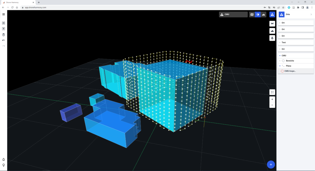
Building and facility inspection planned in Drone Harmony Web
Which are the learning goals of the photogrammetry education program?
In the photogrammetry modules, the students approach the processes of digital aerial photogrammetry with theory and practical implementations. They start with the most important properties of modern airborne sensors and the basics of single and multi-image orientation. Then they master the leading methods for direct and integrated georeferencing and DEM, orthophoto, and 3D model generation. They gain knowledge to efficiently plan and execute surveying missions with drones and the quality of the generated products.
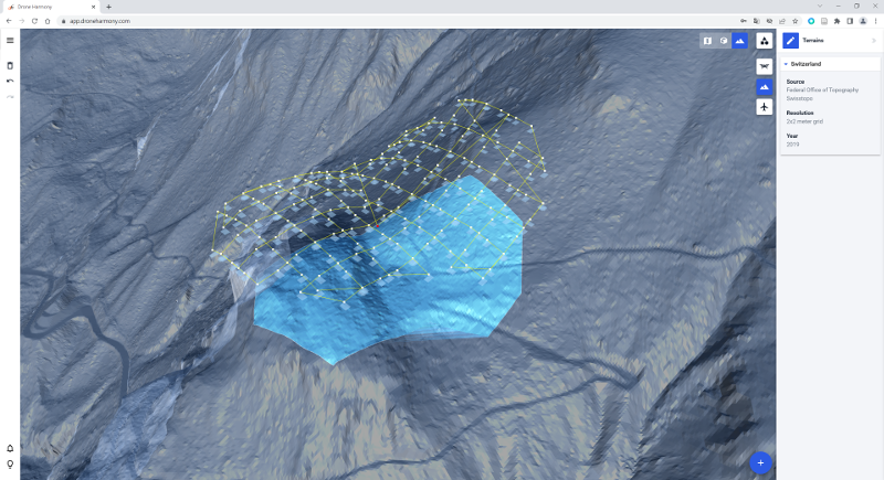
Terrain view of a flight mission in Drone Harmony Web
How do you employ Drone Harmony?
We use Drone Harmony particularly in the bachelor program to show the students a practical application of the theory and methods learned regarding mission planning and execution with a drone. In addition, the software is adopted within projects of the master program or for our research projects to plan the missions rapidly when aerial data is required.
How is the instructional program structured and themed throughout the year?
During the 3rd semester of the bachelor’s degree, the students are introduced to the theme with theory and practical exercises on the whole workflow of digital aerial photogrammetry. In this context, they can verify their flight plan calculations with the help of Drone Harmony, as well as execute their missions to collect the data, which will be elaborated further during the semester.
How will the skills gained through this training benefit students in their future academic or professional careers?
One of the main fields of geomatics is photogrammetry, especially when it comes to geo-referenced data. Creating digital terrain models, orthophotos, and 3D models, and planning and executing building and infrastructure inspections are recurrent tasks for geomatics engineers. All the necessary skills to carry out these tasks are gained during the bachelor program. These skills are also helpful to continue the education beyond the bachelor, especially if one would like to pursue further the fields of computer vision and digital image processing.
Which drones and cameras do you use?
We have some DJI Phantom 4 Pro, a couple of fixed wings eBee, and the last addition to the fleet, a DJI Mavic 3 Thermal.
Thank you, Stephan, for these exciting insights into your work, and keep up the safe flights!
Industries
Business intelligence derived from drone data is only as good as the data that is used to generate it.
Drone harmony would have to be the best equipped flight planning app I've ever used. It works perfectly for vertical and complex structures, along with a large number of mission types to achieve the best results for your target asset.
Danny Elassad, Chief Remote Pilot,Hoverscape
Drone Harmony is the best Flight Planning Platform I've used to cover the dynamic terrain of our mining business with it's Terrain Following feature.
Muhammad Ilyas, Deputy Manager Mine Planning,Sindh Engro Coal Mining Company (SECMC)
Amazing app, easy to use and powerful. Offers all the things I need for scene inspection of many kinds (towers, antennas, construction sites, private residential zones, etc...). Also good mapping grids and parameters setting.
Jose Benitez, Co-Founder,TucanoRobotics
Excellent application, it is worth going for the paid version. It works perfectly, even with simple drones like DJI Spark.
Luis Eduardo Cuevas Correa, Founder,Lekazo
Obtaining a point cloud of the entire site in a few hours using a drone is a huge benefit to the schedule and the budget.
Jesse Creech, VDC Coordinator,Brasfield & Gorrie
Drone Harmony
proved itself admirably, and we
achieved in automated flight what
would have taken enormous risk
and complexity in manual flight.
Michael Appleyard, CEO,Drone Inspection WA
Setting up our missions in Drone Harmony has been easy thanks to great tutorials and excellent support from the Drone Harmony Team. Thank you!
Dwayne Marx, Founder
With the Drone Harmony application
data acquisition was consistent, the flight
patterns and automation provided
us with consistent high-quality models
for the purposes of tower
inspections.
Stanley du Toit, Solution Architect,The iGlobe Group
Legislative Update On June 18, 2024, the House of Representatives passed the National Defense Authorization Act (NDAA), which includes the “Countering CCP Drones Act.” This bill aims to ban DJI drones by prohibiting their use of FCC communication infrastructure. However, the Senate Armed Services Committee (SASC) has recently released its marked-up version of the 2025...
We’ve added ‘tap focus’, by clicking on any point in a live DJI Dock video feed from your drone, the drone will focus its camera on this designated area. This feature gives users never-before-seen real-time control of their drones, allowing them to pinpoint critical areas with unprecedented precision. In addition, we have also made further...
We’re thrilled to announce a major update that combines all versions of our app into one streamlined platform, providing enhanced convenience and efficiency for both enterprise and professional users. Consolidation of Versions With this update, we have merged all versions of the app into a single comprehensive platform. This consolidation includes: Improved Accessibility Upon opening...