How A Florida Fire Fighter Uses Drone Harmony for Search and Rescue Missions
An interview with Bryn Le Rue, a Florida Fire Fighter, Public Safety Drone Instructor and Drone Search and Rescue Volunteerthat utilizes Drone Harmony for faster and more efficient search and rescue missions.
Bryn Le Rue, Fire Fighter, Public Safety Drone Instructor and Drone Volunteer Search and Rescuer
Drone Harmony: Are drone inspections for search and rescue already established in Florida or the United States?
Bryn Le Rue: Currently in Florida or the US not many Fire Departments or Search and Rescue (S&R) agencies are using inspection software for this kind of work. Some use waypoint placing software to set their own waypoints. But this is a long process and even more so one tries to achieve a consistent search pattern. Some are mapping software such as Pix4D, whilst the majority still fly manually. In contrast, a search area using Drone Harmony can be planned and flown within minutes. Drone programs are becoming more popular within the public safety sector and fire departments and are growing fast. Generally, there is increasing understanding that with the use of drone technology S&R and disaster response can be done much faster and more accurately.
For which S&R operations do you use Drone Harmony?
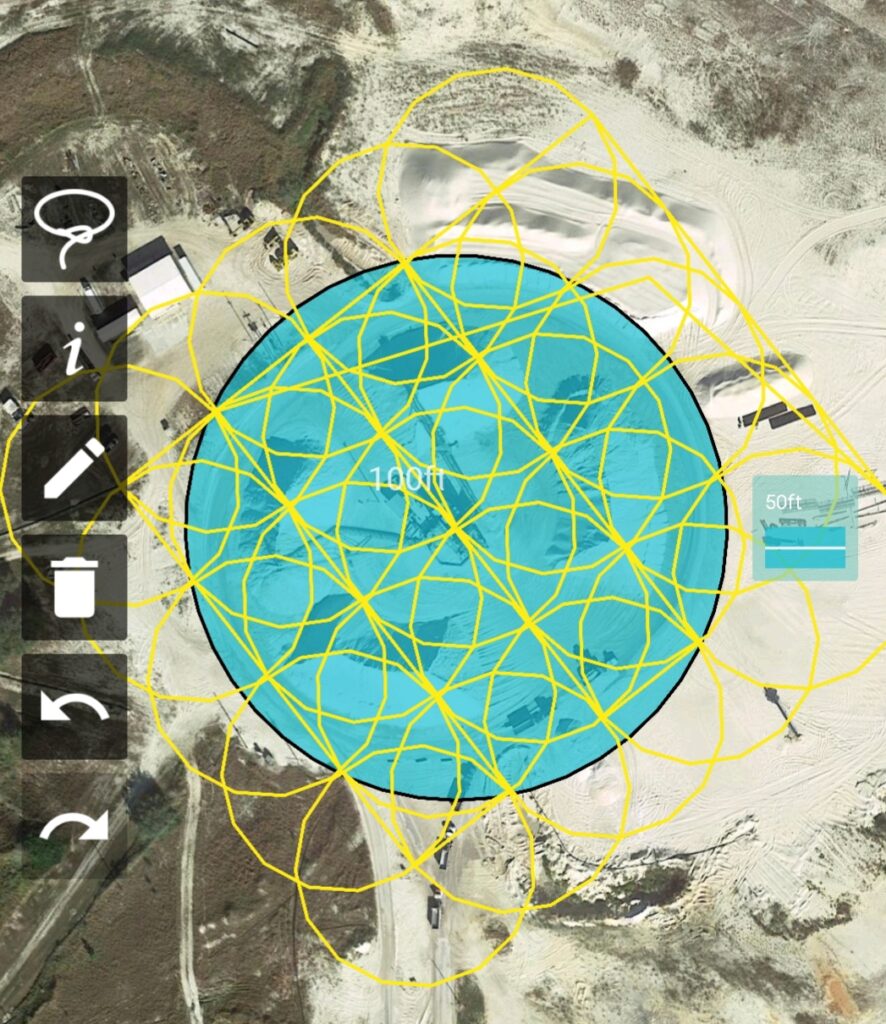
I have been using Drone Harmony for large search areas of land, water and complex industrial sites that would be too complex and difficult on foot. The ease of the software enables the pilot to plot a specific area via the app and upload different patterns and inspections based on the last possible location of the victim that needs to be searched for. Once the area has been set along with the flight altitude, the search pattern gets uploaded to the drone and the mission takes place autonomously. A major plus is that the drone flies autonomously throughout the planned mission flawlessly with Drone Harmony.
Inspections based on the last possible location of the victim.
Whilst the drone is flying the planned search area the pilot can deploy other members of the team to scan the captured photos of the search area for any victims. These photos can also be viewed in more detail at the end of the mission to aid and speed up the S&R operation on foot. The pilot also has first person view of the search area to spot for missing victims and communicate to command staff and ground crews of vital information.
How much time do you need for planning and executing the mission?
I use Drone Harmony as soon as being on scene to set the planned area and execute the mission. This can be done within minutes of arrival which drastically speeds up the initial search, while enabling an accurate search pattern that can be monitored through out the entire mission. I have also been pro active and set preloaded areas that may or have been areas of searches in the past. That has made the execution of the mission even faster, I just have to set the flight altitude and execute the mission. Drone Harmony has definitely made search and rescue faster, more accurate and more professional from how I used to do it.
What are the challenges that you are facing when performing such work?
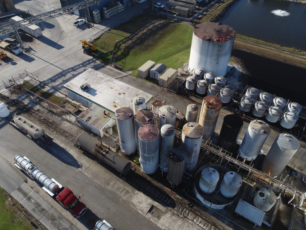
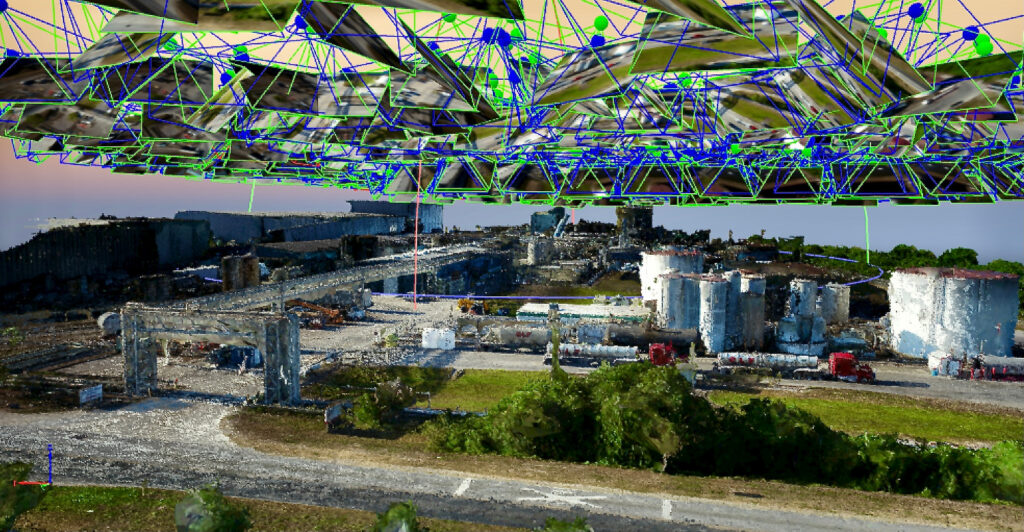
Prior to using Drone Harmony setting accurate search patterns was a huge challenge having the possibility of missing a certain area. Also large complex industrial sites make emergency response more difficult and more complex due to hazards, height, complexity and more. Drone Harmony has enabled me to perform a survey of the area prior to an emergency happening so that crews responding have as much information about the site, hazards, chemicals, confined space, hydrant location, fire pump location and more. Thorough drone inspections planned and executed using Drone Harmony’s software and then converted into a 3D model that can be sent to other departments for safety training on complex sites.
Information about the site, hazards, chemicals, confined space, hydrant location, fire pump locations, height and more are crucial
3D model that can be sent to other departments for safety training
Photos and models can be used to zoom in on any area of the site, providing the necessary information on the hazards, distances from hydrants, volume of water that may be needed for drafting, length of hose lays from the fire pump to the most dangerous areas, the height of the tallest buildings and the best anchor points for rope rescue, areas of confined space… The list of information is endless and a huge benefit to keeping personnel safe not only at the site but to responding personnel.
Since when do you use Drone Harmony? Have you been using another software before?
I used to fly manually on missions, sometimes using Litchi until I saw a blog post on Drone Harmony inspections. I immediately saw the opportunity to do the same kind of planned missions for S&R or disaster response to gain as accurate and as much information as possible. Prior to using Drone Harmony missions were not as precise. Search areas could easily been missed, but with the ability to set accurate flight plans with Drone Harmony, this is a thing of the past.
How did Drone Harmony help your S&R operations and teams?
Faster and safer and more accurate search patterns
Enabled the ability to view photos, video footage, drone flight paths or first person view of a search
Enabled the possibility to prepare possible search areas from previous missions that can be planned ahead ready to fly
Made S&R missions more professional
Some areas having limited or no cell reception make the planning process a little slower in the field, but event then we are a lot faster than earlier, when we did not use Drone Harmony.
Thank you very much Bryn for these interesting insights.
Industries
Business intelligence derived from drone data is only as good as the data that is used to generate it.
Drone harmony would have to be the best equipped flight planning app I've ever used. It works perfectly for vertical and complex structures, along with a large number of mission types to achieve the best results for your target asset.
Danny Elassad, Chief Remote Pilot,Hoverscape
Drone Harmony is the best Flight Planning Platform I've used to cover the dynamic terrain of our mining business with it's Terrain Following feature.
Muhammad Ilyas, Deputy Manager Mine Planning,Sindh Engro Coal Mining Company (SECMC)
Amazing app, easy to use and powerful. Offers all the things I need for scene inspection of many kinds (towers, antennas, construction sites, private residential zones, etc...). Also good mapping grids and parameters setting.
Jose Benitez, Co-Founder,TucanoRobotics
Excellent application, it is worth going for the paid version. It works perfectly, even with simple drones like DJI Spark.
Luis Eduardo Cuevas Correa, Founder,Lekazo
Obtaining a point cloud of the entire site in a few hours using a drone is a huge benefit to the schedule and the budget.
Jesse Creech, VDC Coordinator,Brasfield & Gorrie
Drone Harmony
proved itself admirably, and we
achieved in automated flight what
would have taken enormous risk
and complexity in manual flight.
Michael Appleyard, CEO,Drone Inspection WA
Setting up our missions in Drone Harmony has been easy thanks to great tutorials and excellent support from the Drone Harmony Team. Thank you!
Dwayne Marx, Founder
With the Drone Harmony application
data acquisition was consistent, the flight
patterns and automation provided
us with consistent high-quality models
for the purposes of tower
inspections.
Stanley du Toit, Solution Architect,The iGlobe Group
Legislative Update On June 18, 2024, the House of Representatives passed the National Defense Authorization Act (NDAA), which includes the “Countering CCP Drones Act.” This bill aims to ban DJI drones by prohibiting their use of FCC communication infrastructure. However, the Senate Armed Services Committee (SASC) has recently released its marked-up version of the 2025...
We’ve added ‘tap focus’, by clicking on any point in a live DJI Dock video feed from your drone, the drone will focus its camera on this designated area. This feature gives users never-before-seen real-time control of their drones, allowing them to pinpoint critical areas with unprecedented precision. In addition, we have also made further...
We’re thrilled to announce a major update that combines all versions of our app into one streamlined platform, providing enhanced convenience and efficiency for both enterprise and professional users. Consolidation of Versions With this update, we have merged all versions of the app into a single comprehensive platform. This consolidation includes: Improved Accessibility Upon opening...