Introducing Drone Harmony’s Cutting-Edge 3D Flight Management Platform for DJI Dock
In the ever-evolving world of drone technology, where precision, safety, and data management are paramount, a groundbreaking solution has emerged: Drone Harmony’s advanced 3D Flight Management Platform for the DJI Dock. Leveraging Drone Harmony’s proprietary FULL-3D technology, this platform offers an unparalleled suite of features that redefine the possibilities of aerial operations. Let’s explore how Drone Harmony changes the game from enhancing data security to revolutionizing flight planning.
Key Features and USPs
Unveiling Unprecedented Data Security
The security of sensitive data is a paramount concern for modern enterprises. Drone Harmony for DJI Dock addresses this concern head-on by providing options for deployment on-premise or within a private network. This approach ensures that critical information remains within your control.
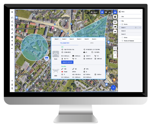
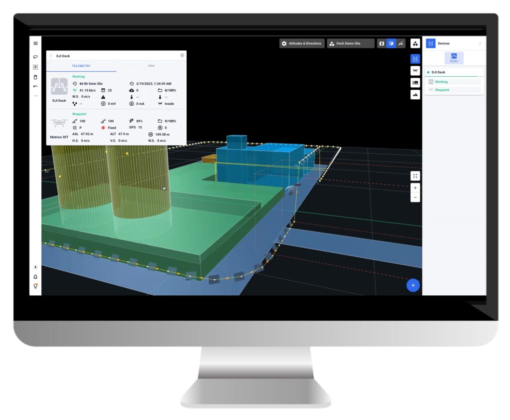
A New Era of Situational Awareness
Imagine having a comprehensive real-time view of your active missions and DJI Docks, all within an intuitive 3D interface. Drone Harmony is the first system to make this a reality. With live feeds from multiple DJI Docks seamlessly integrated into a realistic virtual environment, users gain unparalleled situational awareness. Critical parameters can be monitored instantaneously, giving operators the insights to make informed decisions.
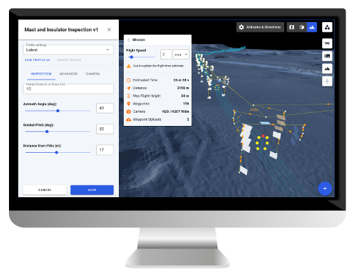
Elevating Flight Safety
Safety is non-negotiable when it comes to drone operations. Drone Harmony takes safety to new heights with its obstacle-avoiding flight planning capabilities. By utilizing custom 3D data and providing visualized plans for review, operators can proactively address potential obstacles before they become hazards. Additionally, the platform empowers users to enforce no-fly zones and geofences, ensuring adherence to regulations and minimizing risks.
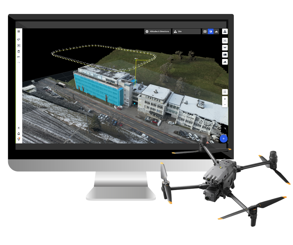
Masterful Flight Planning & Management
The heart of any drone operation lies in effective flight planning and management. Drone Harmony takes this to the next level with automated features and powerful plan adjustment tools. The platform’s versatility, from 2D and 3D mapping to tower inspection and search and rescue missions, is unmatched. With streamlined planning workflows, enterprises can efficiently execute various missions.
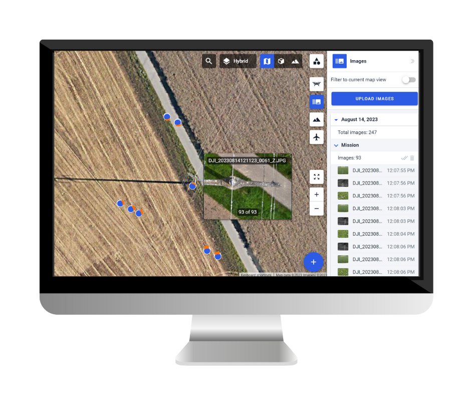
Effortless Image Data Management
Captured images are intelligently organized by time, date, dock, and flight, making post-mission analysis a breeze. The automatic geolocation of images and their overlay on maps and 3D views transforms data into actionable insights, further enhancing decision-making processes.
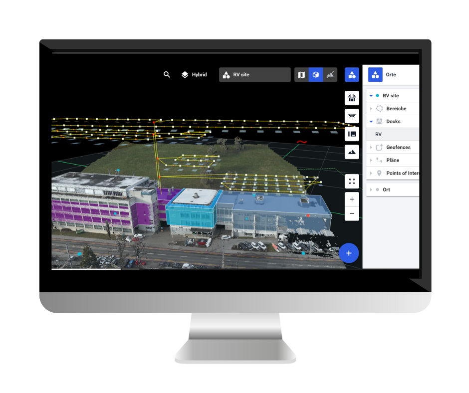
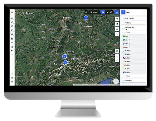
Seamless Site & Dock Management
For organizations managing multiple sites, scalability and efficiency are paramount. Drone Harmony streamlines this process by offering a single, intuitive interface for managing diverse sites. Scaling operations becomes as simple as adding a new site to the enterprise account, enabling organizations to expand their reach quickly.
Visualizing the Future
Drone Harmony’s FULL-3D environment brings a new dimension to aerial operations. With the ability to visualize DJI Dock sites in rich 3D, complete with terrain models and point clouds, the platform unlocks a level of understanding that was previously elusive. This immersive experience empowers operators to make more informed decisions and extract deeper insights from their data.
A Note on DJI Dock
The DJI Dock is a pivotal piece of this technological puzzle. Rapid charging capabilities, active temperature control, and versatile camera options perfectly complement Drone Harmony’s capabilities. The integration of wide, zoom, and thermal cameras, along with a laser rangefinder, equips operators with an all-encompassing toolkit for aerial inspection and survey missions.
In conclusion, Drone Harmony’s 3D Flight Management Platform for DJI Dock is a game-changer in drone technology. From enhancing data security to providing unprecedented situational awareness and revolutionizing flight planning, this platform sets a new standard for aerial operations. As enterprises seek to maximize the potential of drone technology, Drone Harmony stands as a beacon of innovation and efficiency.
Schedule a captivating demo of Drone Harmony’s revolutionary 3D Flight Management Platform for DJI Dock today!
Industries
Business intelligence derived from drone data is only as good as the data that is used to generate it.
Drone harmony would have to be the best equipped flight planning app I've ever used. It works perfectly for vertical and complex structures, along with a large number of mission types to achieve the best results for your target asset.
Danny Elassad, Chief Remote Pilot,Hoverscape
Drone Harmony is the best Flight Planning Platform I've used to cover the dynamic terrain of our mining business with it's Terrain Following feature.
Muhammad Ilyas, Deputy Manager Mine Planning,Sindh Engro Coal Mining Company (SECMC)
Amazing app, easy to use and powerful. Offers all the things I need for scene inspection of many kinds (towers, antennas, construction sites, private residential zones, etc...). Also good mapping grids and parameters setting.
Jose Benitez, Co-Founder,TucanoRobotics
Excellent application, it is worth going for the paid version. It works perfectly, even with simple drones like DJI Spark.
Luis Eduardo Cuevas Correa, Founder,Lekazo
Obtaining a point cloud of the entire site in a few hours using a drone is a huge benefit to the schedule and the budget.
Jesse Creech, VDC Coordinator,Brasfield & Gorrie
Drone Harmony
proved itself admirably, and we
achieved in automated flight what
would have taken enormous risk
and complexity in manual flight.
Michael Appleyard, CEO,Drone Inspection WA
Setting up our missions in Drone Harmony has been easy thanks to great tutorials and excellent support from the Drone Harmony Team. Thank you!
Dwayne Marx, Founder
With the Drone Harmony application
data acquisition was consistent, the flight
patterns and automation provided
us with consistent high-quality models
for the purposes of tower
inspections.
Stanley du Toit, Solution Architect,The iGlobe Group
Legislative Update On June 18, 2024, the House of Representatives passed the National Defense Authorization Act (NDAA), which includes the “Countering CCP Drones Act.” This bill aims to ban DJI drones by prohibiting their use of FCC communication infrastructure. However, the Senate Armed Services Committee (SASC) has recently released its marked-up version of the 2025...
We’ve added ‘tap focus’, by clicking on any point in a live DJI Dock video feed from your drone, the drone will focus its camera on this designated area. This feature gives users never-before-seen real-time control of their drones, allowing them to pinpoint critical areas with unprecedented precision. In addition, we have also made further...
We’re thrilled to announce a major update that combines all versions of our app into one streamlined platform, providing enhanced convenience and efficiency for both enterprise and professional users. Consolidation of Versions With this update, we have merged all versions of the app into a single comprehensive platform. This consolidation includes: Improved Accessibility Upon opening...