A cell tower inspection with a drone became a single-click operation, with minimal risk and a guarantee of high-quality reproducible results. The way to achieve this is by automating the three main steps: data capture, digital model reconstruction, 3D-model-based analytics, and report generation. And, of course, all of this is to be streamlined into a single seamless workflow.
Let’s break this down into the main cost-saving pieces:
Less time on site: Automated data capture with a drone is faster by an order of magnitude.
No special training needed: An automated drone inspection can be carried out by any engineer with minimal drone training, as opposed to traditional inspections that required experienced climbers.
Complete and accurate data: With a drone, it is possible to capture the tower at ultra-high resolution from all angles. This data can be fed into photogrammetry software to create a digital model of the tower which can be the basis of a much more complete and in-depth inspection. These models can also be fed into an analytics program for automatic detection of corrosion and report generation.
Huge reduction in risk: Climbing towers represent one of the most dangerous jobs.
The result is a significantly faster process dramatically reducing the time spent on site, which can be performed by almost any engineer with minimal drone training and with literally no injury risk whatsoever.
This is to be compared with traditional inspections consisting of a highly skilled engineer climbing the tower to visually inspect some components, and collect imagery from some angles to later inspect in the office.
The iGlobe Groupe is overwhelmed by Drone Harmony
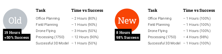
The iGlobe Group which is a specialized integrator, focusing on geospatial orientated applications in the mining, municipality, utility, and private sector, has already tested Drone Harmony Cell Tower Scan extensively. Both managers and pilots are enthusiastic about this app. They were able to reduce the inspection time from 19 to just 8 hours and drastically increase the quality of the deliverable.
Drone harmony would have to be the best equipped flight planning app I've ever used. It works perfectly for vertical and complex structures, along with a large number of mission types to achieve the best results for your target asset.
Danny Elassad, Chief Remote Pilot,Hoverscape
Drone Harmony is the best Flight Planning Platform I've used to cover the dynamic terrain of our mining business with it's Terrain Following feature.
Muhammad Ilyas, Deputy Manager Mine Planning,Sindh Engro Coal Mining Company (SECMC)
Amazing app, easy to use and powerful. Offers all the things I need for scene inspection of many kinds (towers, antennas, construction sites, private residential zones, etc...). Also good mapping grids and parameters setting.
Jose Benitez, Co-Founder,TucanoRobotics
Excellent application, it is worth going for the paid version. It works perfectly, even with simple drones like DJI Spark.
Luis Eduardo Cuevas Correa, Founder,Lekazo
Obtaining a point cloud of the entire site in a few hours using a drone is a huge benefit to the schedule and the budget.
Jesse Creech, VDC Coordinator,Brasfield & Gorrie
Drone Harmony
proved itself admirably, and we
achieved in automated flight what
would have taken enormous risk
and complexity in manual flight.
Michael Appleyard, CEO,Drone Inspection WA
Setting up our missions in Drone Harmony has been easy thanks to great tutorials and excellent support from the Drone Harmony Team. Thank you!
Dwayne Marx, Founder
With the Drone Harmony application
data acquisition was consistent, the flight
patterns and automation provided
us with consistent high-quality models
for the purposes of tower
inspections.
Stanley du Toit, Solution Architect,The iGlobe Group
Legislative Update On June 18, 2024, the House of Representatives passed the National Defense Authorization Act (NDAA), which includes the “Countering CCP Drones Act.” This bill aims to ban DJI drones by prohibiting their use of FCC communication infrastructure. However, the Senate Armed Services Committee (SASC) has recently released its marked-up version of the 2025...
We’ve added ‘tap focus’, by clicking on any point in a live DJI Dock video feed from your drone, the drone will focus its camera on this designated area. This feature gives users never-before-seen real-time control of their drones, allowing them to pinpoint critical areas with unprecedented precision. In addition, we have also made further...
We’re thrilled to announce a major update that combines all versions of our app into one streamlined platform, providing enhanced convenience and efficiency for both enterprise and professional users. Consolidation of Versions With this update, we have merged all versions of the app into a single comprehensive platform. This consolidation includes: Improved Accessibility Upon opening...