Tool to Platform: Summarizing 2019 And Projecting 2020
In 2019 Drone Harmony made the transition from a leading data capture mobile app for digitizing vertical infrastructure to a data acquisition platform capable of not only automating, but also organizing and streamlining digitalization efforts of large enterprises. So what’s in store for 2020?
In 2019 we released Drone Harmony Cloud, our web-based planning platform and cloud service. We’ve build Drone Harmony Cloud to become our customers’ focal point for planning drone operations. The enterprise digitalization engineer can use Drone Harmony Cloud to easily plan hundreds of complex flight missions across a complex asset portfolio and automatically allocate tasks to operators in the filed using the platform’s automated collaboration features.
The Drone Harmony Platform
Furthermore, we’ve advanced and refined our mobile application, enhancing even further its usability, automation and safety features. We have integrated the mobile app with Drone Harmony Cloud, giving rise to the first data capture platform based on 3D data and automation of mission planning in vertical infrastructure markets.
In 2020, the Drone Harmony platform will make further leaps towards a fully-automated enterprise platform for drone-based digitalization.
Added value
When it comes to digitalization, the value for enterprises lies in the ability to quickly access actionable business intelligence based on the digital workflow. This is why, we have decided to bring the drone data and associated insights into Drone Harmony Cloud.
Consequently, the key evolution of Drone Harmony’s platform in 2020 will be the incorporation of captured and processed drone data. The Drone Harmony Cloud will be extended to support drone data storage. The web-based planning platform will include features enabling the visualization and navigation of captured data. This, in turn, will enable further planning of data acquisition, based on key insights revealed by the captured and overlaid data.
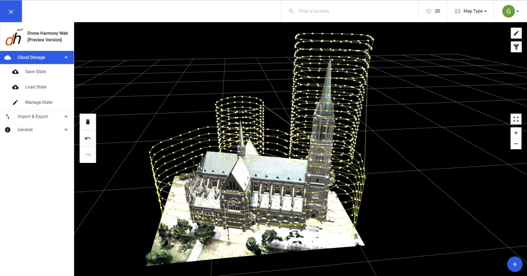
In 2020 we will bring drone data into Drone Harmony Cloud. A 3D model of Church created by Drone Harmony’s Partner Softdesk displayed in Drone Harmony Cloud.
Additional drone platforms
With the introduction of Drone Harmony Cloud, we have created the necessary separation between our primary mission planing and flight execution tools. This separation is key for integrating the platform into enterprise workflows. In addition, this is an opportunity to enable users of a wider range of drone platforms to gain access to our products. In 2020 we will integrate Drone Harmony Cloud with a number of leading drone platforms, ranging from proprietary platforms, to ones based on open source standards, such as PX4.
The future of drone-based digitalization
Last but not least, we will keep on pushing the boundaries of our planning automation technology, making Drone Harmony the most attractive option on the market for enterprises seeking to reliably scale their drone-based digital workflows.
The future of drone-based digitalization is in higher automation – based on model data.
If there is one key new insight we have gained in 2019 it is the following: Most enterprises engaged in digital workflows for their infrastructure assets today already have descriptive data about their asset and environment and they are eager to use this in order to automate their workflows. This trend confirms our vision regarding the future of automation in this industry: It will rely on diverse and rich 3D complex data. In 2020, Drone Harmony will continue pushing this technology towards new standards of efficiency and automation.
Drone harmony would have to be the best equipped flight planning app I've ever used. It works perfectly for vertical and complex structures, along with a large number of mission types to achieve the best results for your target asset.
Danny Elassad, Chief Remote Pilot,Hoverscape
Drone Harmony is the best Flight Planning Platform I've used to cover the dynamic terrain of our mining business with it's Terrain Following feature.
Muhammad Ilyas, Deputy Manager Mine Planning,Sindh Engro Coal Mining Company (SECMC)
Amazing app, easy to use and powerful. Offers all the things I need for scene inspection of many kinds (towers, antennas, construction sites, private residential zones, etc...). Also good mapping grids and parameters setting.
Jose Benitez, Co-Founder,TucanoRobotics
Excellent application, it is worth going for the paid version. It works perfectly, even with simple drones like DJI Spark.
Luis Eduardo Cuevas Correa, Founder,Lekazo
Obtaining a point cloud of the entire site in a few hours using a drone is a huge benefit to the schedule and the budget.
Jesse Creech, VDC Coordinator,Brasfield & Gorrie
Drone Harmony
proved itself admirably, and we
achieved in automated flight what
would have taken enormous risk
and complexity in manual flight.
Michael Appleyard, CEO,Drone Inspection WA
Setting up our missions in Drone Harmony has been easy thanks to great tutorials and excellent support from the Drone Harmony Team. Thank you!
Dwayne Marx, Founder
With the Drone Harmony application
data acquisition was consistent, the flight
patterns and automation provided
us with consistent high-quality models
for the purposes of tower
inspections.
Stanley du Toit, Solution Architect,The iGlobe Group
Legislative Update On June 18, 2024, the House of Representatives passed the National Defense Authorization Act (NDAA), which includes the “Countering CCP Drones Act.” This bill aims to ban DJI drones by prohibiting their use of FCC communication infrastructure. However, the Senate Armed Services Committee (SASC) has recently released its marked-up version of the 2025...
We’ve added ‘tap focus’, by clicking on any point in a live DJI Dock video feed from your drone, the drone will focus its camera on this designated area. This feature gives users never-before-seen real-time control of their drones, allowing them to pinpoint critical areas with unprecedented precision. In addition, we have also made further...
We’re thrilled to announce a major update that combines all versions of our app into one streamlined platform, providing enhanced convenience and efficiency for both enterprise and professional users. Consolidation of Versions With this update, we have merged all versions of the app into a single comprehensive platform. This consolidation includes: Improved Accessibility Upon opening...