Platform Update: New Plans and Terrain Planning for Everyone
Terrain-aware flight planning is among the most versatile forms of automated missions planning. With the latest update, the Drone Harmony platform now offers the most advanced terrain-aware planning capabilities on the market for anyone anywhere in the world.With these major changes we have also updated our subscription plans.
The need to account for differences in elevation is among the most ubiquitous aspects of drone data acquisition. It is a key requirement in many industries from surveying through inspection of linear infrastructure to mapping of open pit mines.
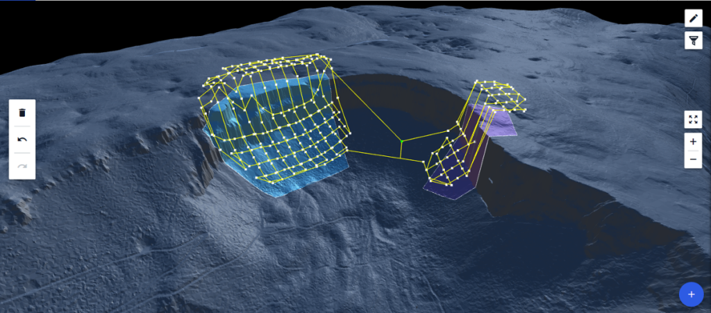
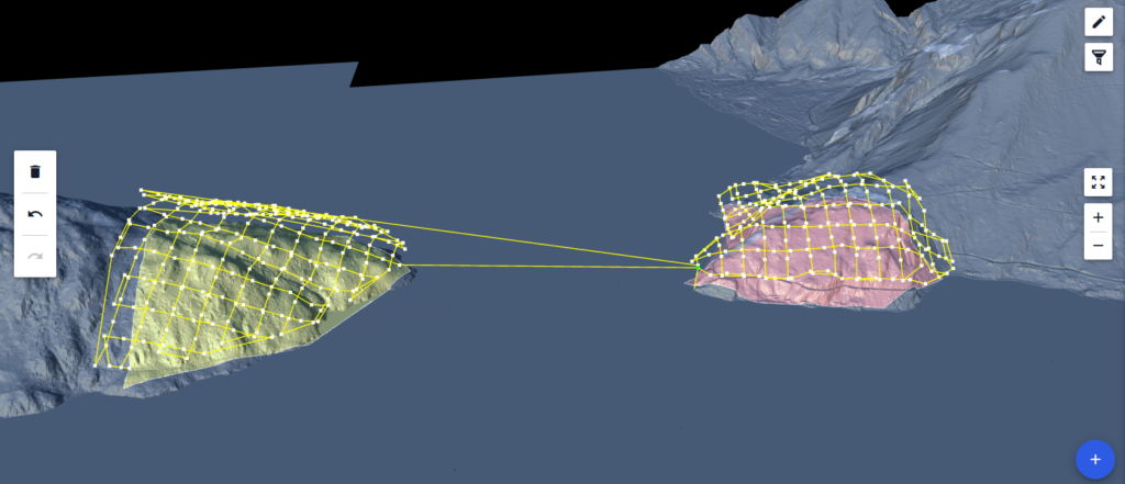
3D Terrain view provides a fully immersive 3D view of the terrain represented by the imported data (see below).
As the most basic 3D data geographic data used in drone data acquisition, the availability and use of terrain data is expanding quickly. Many organizations are compiling and updating their own terrain data sets, while large geo-spatial data providers offer terrain data globally through direct data integrations. With Drone Harmony Web, users can now profit from automated terrain-aware missions planning by using both their own custom terrain maps, as well as the newly-integrated Airbus WorldDEM 12 meter grid global data set.
In case of large terrain files, the navigation in 3D Terrain is extremely easy and intuitive: simply drag and rotate the 3D view to see different parts of the terrain, or to change the point of view.
Drone Harmony customers can upload terrain files in the geotiff (*.tif) file format to Drone Harmony in any coordinate system and accuracy. The files are then processed by the Drone Harmony Cloud and prepared for loading and mission planning in Drone Harmony Web. Customers that do not have custom terrain can profit from a global source of accurate terrain data without ever leaving the Drone Harmony application. With a few clicks in the web interface, customers can pull terrain data anywhere in the world and start planning missions.
The combination of flexible import options together with the brand new 3D Terrain view and rich new plan catalog for terrain aware flight planning in Drone Harmony Web makes it the most comprehensive tool for mapping and inspection in complex terrains. Furthermore, larger organizations with massive amounts of terrain data can profit from a built-in terrain streaming feature in Drone Harmony Web. This feature enables such customers to work with huge terrain models hassle-free, without the need to load terrain models in parts and worry about memory and processing limits.
To reflect the new features and capabilities, we have also updated our subscription plans. For all details on the new changes see our pricing page.
Drone harmony would have to be the best equipped flight planning app I've ever used. It works perfectly for vertical and complex structures, along with a large number of mission types to achieve the best results for your target asset.
Danny Elassad, Chief Remote Pilot,Hoverscape
Drone Harmony is the best Flight Planning Platform I've used to cover the dynamic terrain of our mining business with it's Terrain Following feature.
Muhammad Ilyas, Deputy Manager Mine Planning,Sindh Engro Coal Mining Company (SECMC)
Amazing app, easy to use and powerful. Offers all the things I need for scene inspection of many kinds (towers, antennas, construction sites, private residential zones, etc...). Also good mapping grids and parameters setting.
Jose Benitez, Co-Founder,TucanoRobotics
Excellent application, it is worth going for the paid version. It works perfectly, even with simple drones like DJI Spark.
Luis Eduardo Cuevas Correa, Founder,Lekazo
Obtaining a point cloud of the entire site in a few hours using a drone is a huge benefit to the schedule and the budget.
Jesse Creech, VDC Coordinator,Brasfield & Gorrie
Drone Harmony
proved itself admirably, and we
achieved in automated flight what
would have taken enormous risk
and complexity in manual flight.
Michael Appleyard, CEO,Drone Inspection WA
Setting up our missions in Drone Harmony has been easy thanks to great tutorials and excellent support from the Drone Harmony Team. Thank you!
Dwayne Marx, Founder
With the Drone Harmony application
data acquisition was consistent, the flight
patterns and automation provided
us with consistent high-quality models
for the purposes of tower
inspections.
Stanley du Toit, Solution Architect,The iGlobe Group
Legislative Update On June 18, 2024, the House of Representatives passed the National Defense Authorization Act (NDAA), which includes the “Countering CCP Drones Act.” This bill aims to ban DJI drones by prohibiting their use of FCC communication infrastructure. However, the Senate Armed Services Committee (SASC) has recently released its marked-up version of the 2025...
We’ve added ‘tap focus’, by clicking on any point in a live DJI Dock video feed from your drone, the drone will focus its camera on this designated area. This feature gives users never-before-seen real-time control of their drones, allowing them to pinpoint critical areas with unprecedented precision. In addition, we have also made further...
We’re thrilled to announce a major update that combines all versions of our app into one streamlined platform, providing enhanced convenience and efficiency for both enterprise and professional users. Consolidation of Versions With this update, we have merged all versions of the app into a single comprehensive platform. This consolidation includes: Improved Accessibility Upon opening...