Image Gallery Feature for Drone Harmony for DJI Dock
At Drone Harmony, we’re committed to providing cutting-edge solutions for drone mission planning and execution. Our latest enhancement, the Image Gallery feature for Drone Harmony for DJI Dock, brings unparalleled convenience and efficiency to managing captured image data. Here’s why this feature will revolutionize your workflow:
Automatic Upload and Organization: As soon as your flight is complete, all captured image data is automatically uploaded, stored, and organized. Say goodbye to manual file transfers and tedious data management tasks.
Captured image data is automatically uploaded, stored, and organized
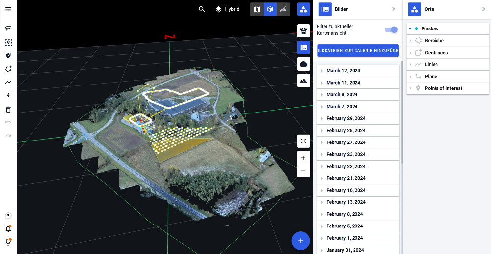
Effortless Navigation: Finding the images you need has never been easier. Our intuitive interface allows you to navigate through your image data by site, date, and mission. The map view provides a comprehensive overview, with images overlaid on both the map view and in 3D, giving you a clear indication of each image’s location relative to the site.
Indication of each image’s location
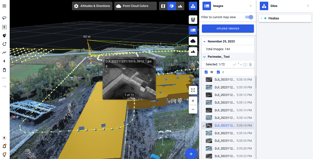
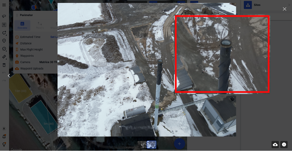
Seamless Browsing Experience: Dive deep into your captured images with our seamless browsing experience. View images in the order they were captured during a specific mission, and effortlessly zoom in and out to inspect every detail. Our user-friendly interface makes exploration a breeze.
Zoom in and out to inspect every detail
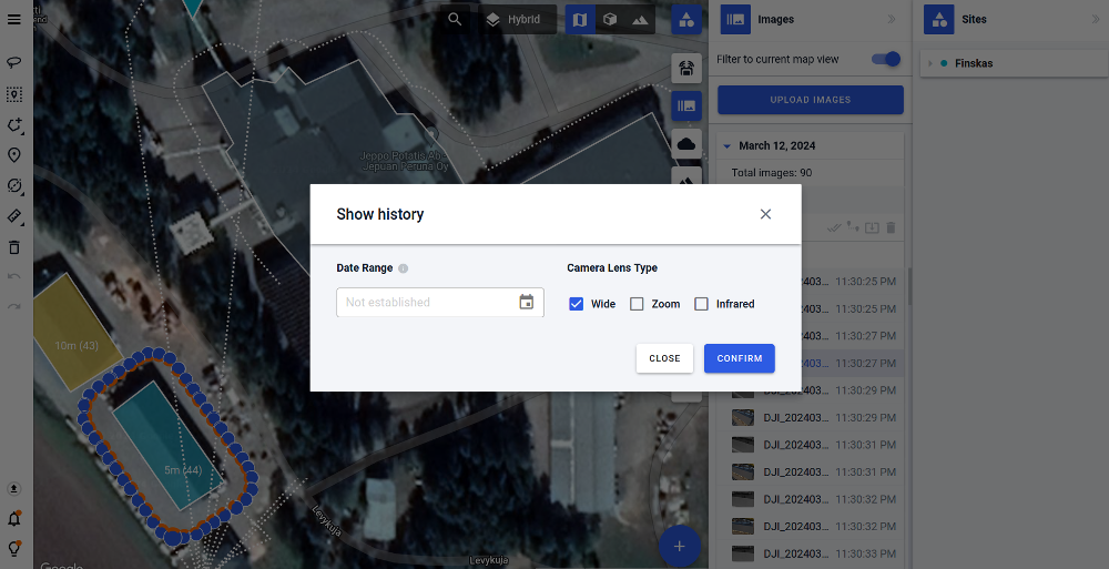
Efficient Comparison Tools: Identifying changes over time is now a simple task. With Drone Harmony, you can easily compare images captured at different times and dates for the same location. Spotting differences and monitoring progress has never been more efficient.
Images filter
Integration with Third-Party Solutions: Harness the power of your image data beyond Drone Harmony. Our API allows seamless access to image data, enabling integration with third-party software solutions. Whether you’re analyzing data or incorporating images into reports, the possibilities are endless.
With the Image Gallery feature for Drone Harmony for DJI Dock, managing captured image data is no longer a hassle – it’s a streamlined process that empowers you to make informed decisions with ease.
Industries
Business intelligence derived from drone data is only as good as the data that is used to generate it.
Drone harmony would have to be the best equipped flight planning app I've ever used. It works perfectly for vertical and complex structures, along with a large number of mission types to achieve the best results for your target asset.
Danny Elassad, Chief Remote Pilot,Hoverscape
Drone Harmony is the best Flight Planning Platform I've used to cover the dynamic terrain of our mining business with it's Terrain Following feature.
Muhammad Ilyas, Deputy Manager Mine Planning,Sindh Engro Coal Mining Company (SECMC)
Amazing app, easy to use and powerful. Offers all the things I need for scene inspection of many kinds (towers, antennas, construction sites, private residential zones, etc...). Also good mapping grids and parameters setting.
Jose Benitez, Co-Founder,TucanoRobotics
Excellent application, it is worth going for the paid version. It works perfectly, even with simple drones like DJI Spark.
Luis Eduardo Cuevas Correa, Founder,Lekazo
Obtaining a point cloud of the entire site in a few hours using a drone is a huge benefit to the schedule and the budget.
Jesse Creech, VDC Coordinator,Brasfield & Gorrie
Drone Harmony
proved itself admirably, and we
achieved in automated flight what
would have taken enormous risk
and complexity in manual flight.
Michael Appleyard, CEO,Drone Inspection WA
Setting up our missions in Drone Harmony has been easy thanks to great tutorials and excellent support from the Drone Harmony Team. Thank you!
Dwayne Marx, Founder
With the Drone Harmony application
data acquisition was consistent, the flight
patterns and automation provided
us with consistent high-quality models
for the purposes of tower
inspections.
Stanley du Toit, Solution Architect,The iGlobe Group
Legislative Update On June 18, 2024, the House of Representatives passed the National Defense Authorization Act (NDAA), which includes the “Countering CCP Drones Act.” This bill aims to ban DJI drones by prohibiting their use of FCC communication infrastructure. However, the Senate Armed Services Committee (SASC) has recently released its marked-up version of the 2025...
We’ve added ‘tap focus’, by clicking on any point in a live DJI Dock video feed from your drone, the drone will focus its camera on this designated area. This feature gives users never-before-seen real-time control of their drones, allowing them to pinpoint critical areas with unprecedented precision. In addition, we have also made further...
We’re thrilled to announce a major update that combines all versions of our app into one streamlined platform, providing enhanced convenience and efficiency for both enterprise and professional users. Consolidation of Versions With this update, we have merged all versions of the app into a single comprehensive platform. This consolidation includes: Improved Accessibility Upon opening...