The Motion of Glaciers: Terrain Aware Scan Helps Monitoring
September 13, 2022
Guillaume Jouvet, Senior researcher in the Department of Geography of the University of Zurich, uses Drone Harmony’s terrain-aware data acquisition for research, monitoring, and mapping of the motion of glaciers in Greenland and Switzerland. We were invited to talk with him.
Guillaume, what is your research about?
As a mathematician and a glaciologist, I’m working on the mechanical motion of ice in a broad sense. My research interest spans from the mathematical aspects of ice flow models to the observation of glacial processes using drones.
Guillaume Jouvet
For what research do you use Drone Harmony?
As a glaciologist, I’m interested in understanding mechanical processes that govern the dynamics of glacier ice. Repeated photogrammetry drone mapping offers a unique opportunity to monitor the motion of glaciers in high spatial and temporal resolution – a task not achievable a couple of years ago. Mapping glaciers on a regular basis allows us to compare their texture and track their mechanical motion (glacier ice is known to flow like a viscous fluid). In turn, this permits us to better understand the underlying processes and to help at modelling their evolution with computer simulations.
Guillaume and his team use drones to monitor and model the detachment of icebergs (calving) from the Bowdoin Glacier in Northwest Greenland.
What are the challenges that you are facing when performing your work?
Flying drones in extreme glacial environments poses several challenges:
1) The weather conditions are in general unstable, windy, and cold;
2) The areas of interest are sometimes hardly (or not) reachable, this forces us to program ad-hoc trajectories to optimize flight time, and data collection;
3) There are a couple of other challenges related to the sensor, e.g. mapping ice requires particular camera parameters. In addition, the remoteness of our terrain poses a certain number of logistical obstacles to carrying the drone and related material, planning spare components, charging batteries, etc.
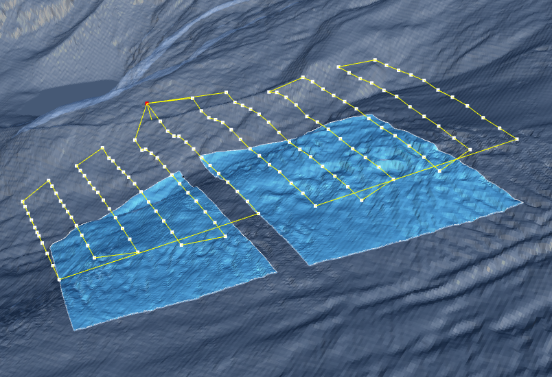
Glacier flight planning with Drone Harmony terrain view
Which drone do you use?
DJI Phantom 4
Are drone inspections in general already established for your kind of work and studies?
Drones are well established to monitor glaciers in general as they permit collecting data in remote and inaccessible areas and collect data where satellite remote sensing is too limited (in terms of resolution). This goes beyond glacier motion: drones serve to quantify climatic processes on the surface of glaciers, albedo, debris covering glaciers, and iceberg calving,…
How much time do you need for planning and executing the mission?
I mainly plan my missions before going on the field, so it is hard to say, but in general, that was fairly quick with the Drone Harmony Web app.
What did using Drone Harmony enable for your research?
The main challenge for mapping glaciers is the complex Alpine topography and the weather conditions that render drone operation more delicate than usual. I found Drone Harmony especially useful as it is designed for truly 3D applications, therefore, the terrain following feature was very handy and reliable. I especially appreciated the 3D visualization of the drone trajectory.
Thank you Guillaume for these exciting insights into your work and keep up the safe flights!
Many thanks to the Drone Harmony team for their efficient support when I was on the field.
Stephan Nebiker, Professor of photogrammetry, remote sensing, and geoinformatics at the Institute of Geomatics Engineering of FHNW, uses Drone Harmony in bachelor and master photogrammetry classes. He teaches students the processes of digital aerial photogrammetry. We were invited to talk with him. Stephan, please introduce yourself. I am a photogrammetry, remote sensing, and geoinformatics professor...
Randy Fulweber, GIS & Remote Sensing Manager for Toolik Field Station at the University of Alaska Fairbanks, makes use of Drone Harmony for research, monitoring and mapping the progression of once permanently frozen ground (permafrost) in northern Arctic Alaska. We were invited to talk with him. Randy, please introduce yourself I am the manager of...
May 6, 2022
Copyright 2024 Drone Harmony AG. All Rights Reserved.