A cell tower inspection with a drone became a single-click operation, with minimal risk and a guarantee of high-quality reproducible results. The way to achieve this is by automating the three main steps: data capture, digital model reconstruction, 3D-model-based analytics, and report generation. And, of course, all of this is to be streamlined into a single seamless workflow.
Let’s break this down into the main cost-saving pieces:
Less time on site: Automated data capture with a drone is faster by an order of magnitude.
No special training needed: An automated drone inspection can be carried out by any engineer with minimal drone training, as opposed to traditional inspections that required experienced climbers.
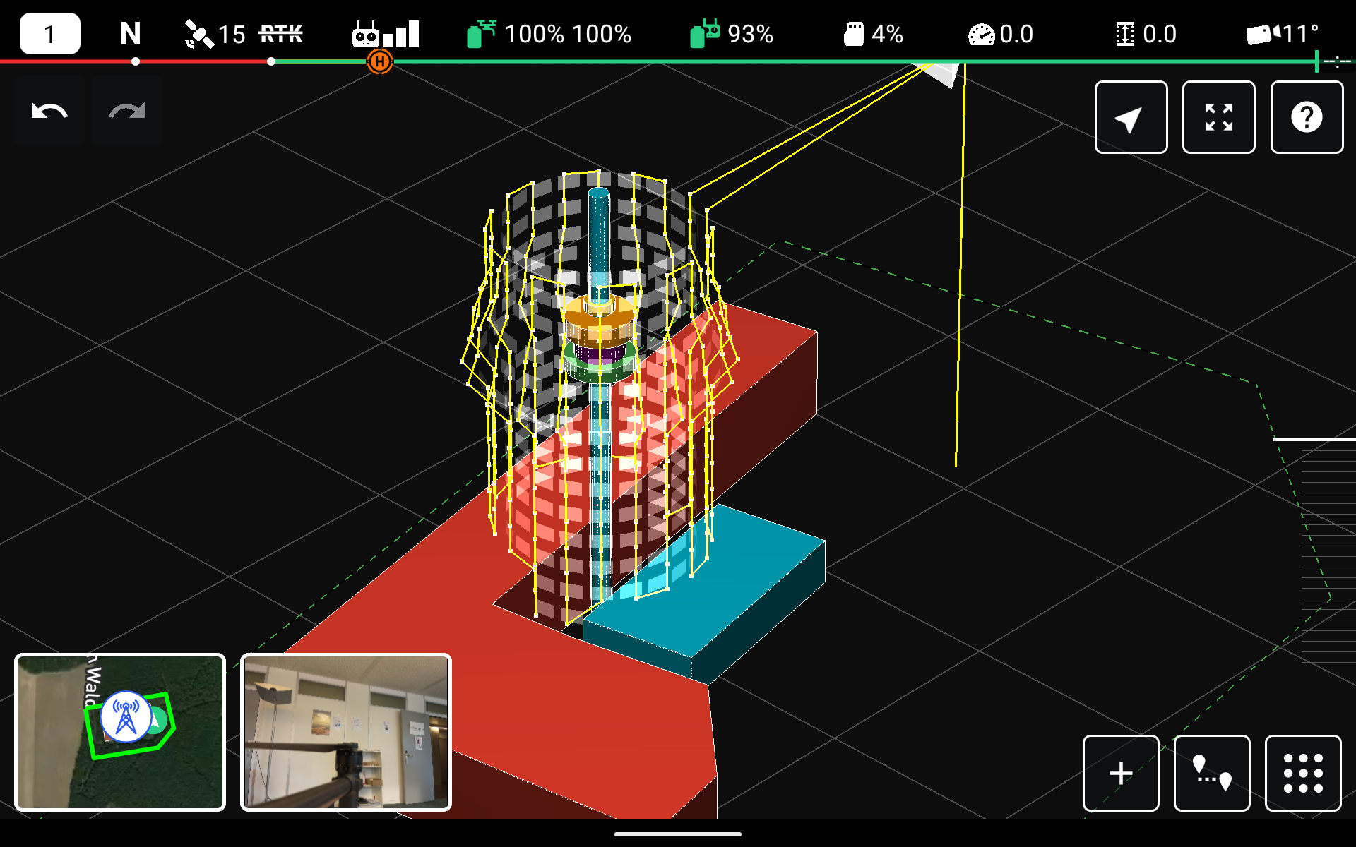
Complete and accurate data: With a drone, it is possible to capture the tower at ultra-high resolution from all angles. This data can be fed into photogrammetry software to create a digital model of the tower which can be the basis of a much more complete and in-depth inspection. These models can also be fed into an analytics program for automatic detection of corrosion and report generation.
Huge reduction in risk: Climbing towers represent one of the most dangerous jobs.
The result is a significantly faster process dramatically reducing the time spent on site, which can be performed by almost any engineer with minimal drone training and with literally no injury risk whatsoever.
This is to be compared with traditional inspections consisting of a highly skilled engineer climbing the tower to visually inspect some components, and collect imagery from some angles to later inspect in the office.
The iGlobe Groupe is overwhelmed by Drone Harmony
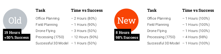
The iGlobe Group which is a specialized integrator, focusing on geospatial orientated applications in the mining, municipality, utility, and private sector, has already tested Drone Harmony Cell Tower Scan extensively. Both managers and pilots are enthusiastic about this app. They were able to reduce the inspection time from 19 to just 8 hours and drastically increase the quality of the deliverable.
The Drone Harmony Tower Scanner for Cell Tower Inspection continues to evolve, offering an extensive range of new features and enhancements. With its new ability to resume missions, improved translation support, real-time data display, and numerous other updates, the app is a valuable tool for tower and antenna inspections. In this blog post, we will...
Drone Harmony has released a new update for its professional drone mission planning software for commercial use. The software now supports all new DJI Enterprise drones, including Mavic 3 Enterprise Thermal, Matrice 30 Thermal, and Matrice 300 RTK. The highlight of the recent release is the new support of the DJI’s Matrice 30 and Mavic...
Stephan Nebiker, Professor of photogrammetry, remote sensing, and geoinformatics at the Institute of Geomatics Engineering of FHNW, uses Drone Harmony in bachelor and master photogrammetry classes. He teaches students the processes of digital aerial photogrammetry. We were invited to talk with him. Stephan, please introduce yourself. I am a photogrammetry, remote sensing, and geoinformatics professor...
March 10, 2023
Copyright 2024 Drone Harmony AG. All Rights Reserved.