Drone Harmony is a software solution designed specifically for drone inspection missions. In this blog post, we will outline the steps involved in performing inspections using Drone Harmony.
Drone technology has transformed the way inspections are carried out across various industries. With the ability to capture high-resolution images and video, drones are becoming increasingly popular for conducting inspections that would otherwise be dangerous, time-consuming, or costly.
Step 1: Plan the Mission
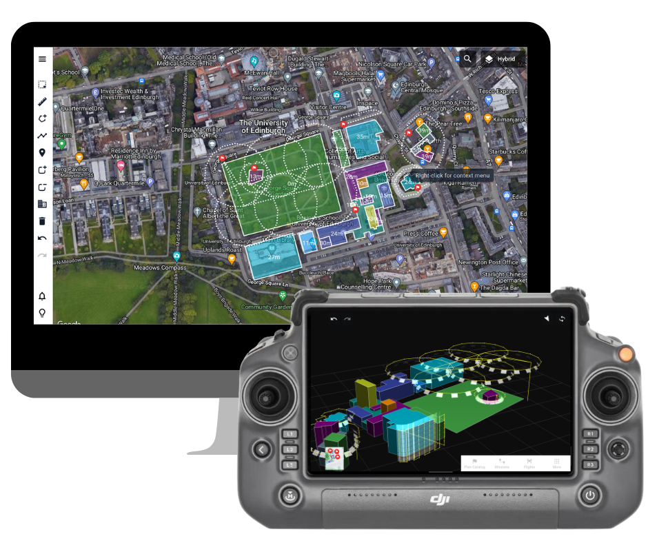
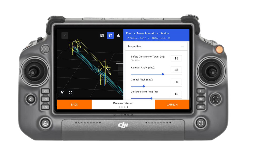
The first step in performing an inspection using Drone Harmony is to plan the mission. With Drone Harmony, mission planning is made easy with its user-friendly interface. Simply select the area of interest and specify the desired resolution and camera angle. The software will automatically generate the most efficient flight path for the drone to follow.
Scene-based flight planning
Step 2: Conduct the Inspection
Once the mission plan is finalized, it’s time to inspect. With Drone Harmony, you can be sure that the drone will fly the mission according to plan, capturing high-resolution images and video of the inspection area. As the drone flies, you can monitor its progress in real-time.
Monitor and adjust the inspection in real-time
Step 3: Review the Data
After the inspection mission is complete, the next step is to review the data captured by the drone. Drone Harmony makes it easy to view, analyze, and interpret the data using its advanced photogrammetry algorithms. The software can be used to create 3D models, orthomosaics, and other visualizations of the inspection area.
Step 4: Generate Reports
Once the data has been analyzed and interpreted, it’s time to generate reports based on the insights gleaned from the data. Although Drone Harmony doesn’t have a built-in report generation feature, the data can be easily exported and integrated into other software solutions that do provide this functionality. For example, the data can be used to create detailed inspection reports, maintenance schedules, or other types of reports that are tailored to the specific needs of your industry.
In conclusion, performing inspections using Drone Harmony is a straightforward process that can save time, improve safety, and increase the accuracy of inspections. With its advanced capabilities and user-friendly interface, Drone Harmony is the ideal solution for carrying out inspections in a range of industries.
We offer a detailed documentation section on our website, covering topics such as mission planning, flight execution, and working with terrain. Our tutorials, video guides, and other resources are designed to help you get up to speed quickly and conduct inspections more efficiently and accurately. Whether you’re new to drone inspections or have extensive experience, we’re committed to supporting you with the resources you need to succeed.
Industries
Business intelligence derived from drone data is only as good as the data that is used to generate it.
Drone harmony would have to be the best equipped flight planning app I've ever used. It works perfectly for vertical and complex structures, along with a large number of mission types to achieve the best results for your target asset.
Danny Elassad, Chief Remote Pilot,Hoverscape
Drone Harmony is the best Flight Planning Platform I've used to cover the dynamic terrain of our mining business with it's Terrain Following feature.
Muhammad Ilyas, Deputy Manager Mine Planning,Sindh Engro Coal Mining Company (SECMC)
Amazing app, easy to use and powerful. Offers all the things I need for scene inspection of many kinds (towers, antennas, construction sites, private residential zones, etc...). Also good mapping grids and parameters setting.
Jose Benitez, Co-Founder,TucanoRobotics
Excellent application, it is worth going for the paid version. It works perfectly, even with simple drones like DJI Spark.
Luis Eduardo Cuevas Correa, Founder,Lekazo
Obtaining a point cloud of the entire site in a few hours using a drone is a huge benefit to the schedule and the budget.
Jesse Creech, VDC Coordinator,Brasfield & Gorrie
Drone Harmony
proved itself admirably, and we
achieved in automated flight what
would have taken enormous risk
and complexity in manual flight.
Michael Appleyard, CEO,Drone Inspection WA
Setting up our missions in Drone Harmony has been easy thanks to great tutorials and excellent support from the Drone Harmony Team. Thank you!
Dwayne Marx, Founder
With the Drone Harmony application
data acquisition was consistent, the flight
patterns and automation provided
us with consistent high-quality models
for the purposes of tower
inspections.
Stanley du Toit, Solution Architect,The iGlobe Group
Legislative Update On June 18, 2024, the House of Representatives passed the National Defense Authorization Act (NDAA), which includes the “Countering CCP Drones Act.” This bill aims to ban DJI drones by prohibiting their use of FCC communication infrastructure. However, the Senate Armed Services Committee (SASC) has recently released its marked-up version of the 2025...
We’ve added ‘tap focus’, by clicking on any point in a live DJI Dock video feed from your drone, the drone will focus its camera on this designated area. This feature gives users never-before-seen real-time control of their drones, allowing them to pinpoint critical areas with unprecedented precision. In addition, we have also made further...
We’re thrilled to announce a major update that combines all versions of our app into one streamlined platform, providing enhanced convenience and efficiency for both enterprise and professional users. Consolidation of Versions With this update, we have merged all versions of the app into a single comprehensive platform. This consolidation includes: Improved Accessibility Upon opening...