How Swiss Federal Railways (SBB) Plans to Use Hill Scan, Drone Harmony’s Newest Technology
According to the European Railway Performance Index, Swiss Federal Railways (SBB) is Switzerland’s largest public transport and mobility company and top performer in its class. Indicative of its innovative approach to operations, SBB has established a Center of Competence for Drones to oversee a wide range of drone applications across the organization. As it stands, over 100 specially trained pilots operate a fleet of over 80 drones in dozens of use cases for SBB.
When it comes to high-quality drone data capture, SBB has been using Drone Harmony’s software for its ease of use and its ability to produce replicable data in complex use cases. One notable example is Hill Scan, Drone Harmony’s newest terrain inspection and mapping technology, which SBB plans to use for inspecting rockslides near railroad tracks.
Inspecting Rockslides Over Railway Infrastructure
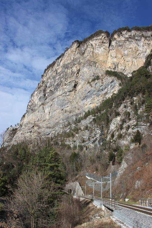
As part of regular maintenance work, SBB must monitor the steep hills and hangs that span directly above railway tracks across Switzerland to identify potential rock- and landslides that could endanger the railway traffic below. There are different methods to monitor such potential rock- and landslides, each having their advantages and disadvantages. Regardless of the method chosen, the main challenges in performing such work relate to the large extent of these areas (at times several square kilometers) and the steep and rugged terrain they cover.
SBB has recently performed a proof of concept to test a new approach consisting of using drone imagery to measure displacement, a useful metric for rockslide monitoring. The new method is designed to compliment traditional methods, such as punctual monitoring to terrestrial laser scanning by adding more insight into what parts of the terrain may require in-depth inspection by other means. Specifically, by using the displacement map, inspectors will be able to prioritize small parts of the terrain with the highest risks, and focus climbing and rappelling work in these areas, instead of performing such work on the entire terrain.
Steep cliff above a railroad in Switzerland requiring regular monitoring.
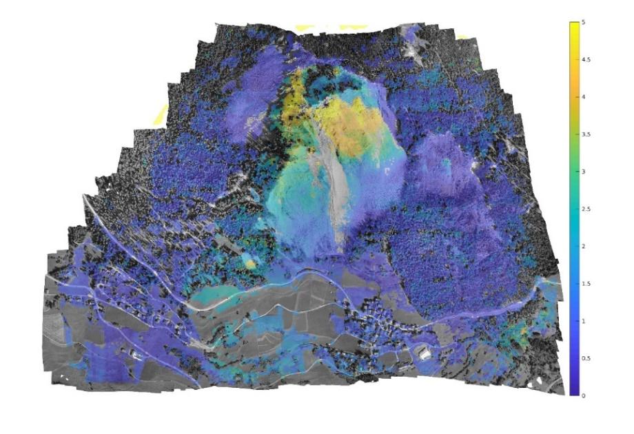
The displacement map is generated from drone images collected using Drone Harmony’s newest technology specifically designed to capture data in very steep and non-uniform terrain calledHill Scan. After the data capture, the images are processed using other software products to generate the end result. Concretely, photogrammetry methods process images captured in successive surveys into orthophotos of the area. The orthophotos are then accurately overlaid to generate the displacement map (see figure below).
These maps classify the inspection site into regions with high and low displacements. Areas with high displacements correspond to the higher displacement of matching points in the successive orthophotos.
A displacement map of a cliff in Brienz, Switzerland, generated by SBB based on drone imagery. Yellow and Orange areas correspond to parts of the cliff with the largest registered displacement.
The image set is captured at various resolutions, allowing inspectors to inspect the area at different detail levels visually. In addition, a 3D model of the cliff is often created for additional visual representation purposes and for planning the construction of protective infrastructure around the cliff. It is foreseen that in the future, the generated 3D models will be used for change analysis as well.
Drone data collection around steep cliffs and uneven terrain present a set of challenges. Nicolas Ackermann, Development Engineer Drones at Drone Competence Centre in SBB, comments:
“Gathering the required drone data is challenging for several reasons. In the past, there was no software solution out there that could automate flight planning. Standard terrain aware planning was not suitable due to the tricky and steep slopes. Hill Scan should solve this problem for us. We also love the simple and very visual workflow in Drone Harmony and how terrain data is handled in the cloud and web app. This will make it possible for us to train dozens of pilots with different skill levels to do this complicated job.
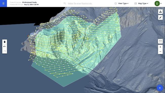
A 3D Terrain model (digital twin) computed from a data set collected with the new Drone Harmony Hill Flight Plan.
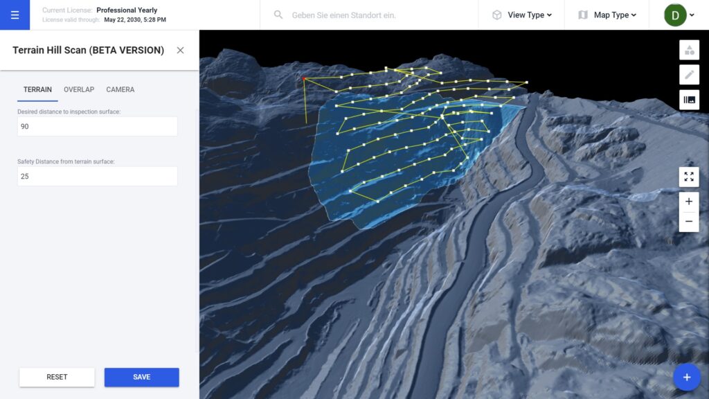
Apart from relying on Hill Scan for generating flight missions for practically any terrain profile, SBB will also benefit from Drone Harmony’s cloud solution to simplify its workflow. For example, the entire terrain data set used by SBB to perform planning across the country is stored in Drone Harmony Cloud. When planning a mission at a new location, SBB inspectors only need to navigate to this location in Drone Harmony Web. From there, they can immediately start planning while the critical terrain data is automatically streamed to the web browser, eliminating the need for file handling and sharing. When the mission is computed, it is simply saved in Drone Harmony Cloud and automatically synchronized to all associated mobile devices, which can then be used to execute the flight using Drone Harmony Mobile.
Terrain streaming in Drone Harmony Cloud. SBB’s engineers can easily work with the entire elevation model of Switzerland.
“There are numerous problematic areas we need to inspect regularly. Most have regular heavy rainfall. Our goal is to provide with this process new monitoring tools to the traditional expensive and dangerous approach, which included sending skilled personnel to survey the terrain by foot or by rappelling down from the top. In the long run, apart from the obvious safety and quality benefits of the drone-based workflow, we are also looking to save time and resources in conducting these activities.”
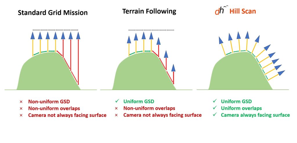
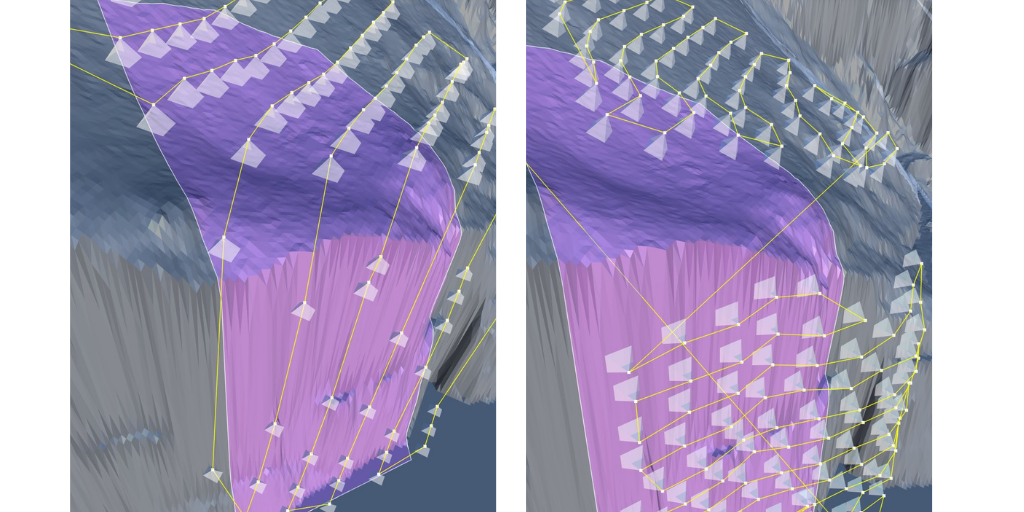
Why do standard terrain-following approaches not cut it? To understand this, one needs to consider what happens when terrain following is used in steeply or non-uniformly sloped terrain. Traditional drone mapping surveys rely on grid missions, which cover the area of interest with nadir images placed on a grid. The spacing between adjacent images is chosen to match an overlap parameter, and the flight altitude is selected according to the desired ground sampling distance (GSD – determines what area of the surface is represented by each pixel in the image). Compared to a standard grid mission, Terrain Following improves the acquisitions by adjusting the height of the flight to the local profile, which ensured a fixed GSD, but does not ensure overlap consistency, nor does it adjust camera angles to the terrain slope. Drone Harmony’s Hill Scan solves all these issues. The following figure gives a visual comparison between the three methods and summarizes their properties.
Cliff inspection using traditional terrain-following (left) vs. Hill Scan (right)
Another valuable attribute of Hill Scan is its flexibility. One can use Hill Scan to map a larger area with varying elevation profiles, without the need to split the region into regions that are coherent in terms of slope or azimuth. As a result, hilly areas can be mapped in combination with flatter areas all in one contiguous mission. In summary, Hill Scan is a powerful tool that can assist in a variety of inspection activities, such as cliff stability assessment, mine site inspection, dam inspections and more. Martin Fuchsberger, Drone Harmony CEO, comments on the relationship with SBB and the future of the technology behind Hill Scan:
Inspection of a mining site planned with Hill Scan
“From the very beginning, we had an open conversation with SBB. We are delighted to see Drone Harmony’s technology delivering added value to SBB for such a safety-critical activity. For Drone Harmony, it is key to align the technology with actual use cases. Hill Scan is an important step forward, but for us, it is just scratching the surface of what the underlying technology can achieve. In the future, we expect to extend it to many use cases, including structural inspection for vertical infrastructure.”
Martin Fuchsberger, Drone Harmony CEO
Industries
Business intelligence derived from drone data is only as good as the data that is used to generate it.
Drone harmony would have to be the best equipped flight planning app I've ever used. It works perfectly for vertical and complex structures, along with a large number of mission types to achieve the best results for your target asset.
Danny Elassad, Chief Remote Pilot,Hoverscape
Drone Harmony is the best Flight Planning Platform I've used to cover the dynamic terrain of our mining business with it's Terrain Following feature.
Muhammad Ilyas, Deputy Manager Mine Planning,Sindh Engro Coal Mining Company (SECMC)
Amazing app, easy to use and powerful. Offers all the things I need for scene inspection of many kinds (towers, antennas, construction sites, private residential zones, etc...). Also good mapping grids and parameters setting.
Jose Benitez, Co-Founder,TucanoRobotics
Excellent application, it is worth going for the paid version. It works perfectly, even with simple drones like DJI Spark.
Luis Eduardo Cuevas Correa, Founder,Lekazo
Obtaining a point cloud of the entire site in a few hours using a drone is a huge benefit to the schedule and the budget.
Jesse Creech, VDC Coordinator,Brasfield & Gorrie
Drone Harmony
proved itself admirably, and we
achieved in automated flight what
would have taken enormous risk
and complexity in manual flight.
Michael Appleyard, CEO,Drone Inspection WA
Setting up our missions in Drone Harmony has been easy thanks to great tutorials and excellent support from the Drone Harmony Team. Thank you!
Dwayne Marx, Founder
With the Drone Harmony application
data acquisition was consistent, the flight
patterns and automation provided
us with consistent high-quality models
for the purposes of tower
inspections.
Stanley du Toit, Solution Architect,The iGlobe Group
Legislative Update On June 18, 2024, the House of Representatives passed the National Defense Authorization Act (NDAA), which includes the “Countering CCP Drones Act.” This bill aims to ban DJI drones by prohibiting their use of FCC communication infrastructure. However, the Senate Armed Services Committee (SASC) has recently released its marked-up version of the 2025...
We’ve added ‘tap focus’, by clicking on any point in a live DJI Dock video feed from your drone, the drone will focus its camera on this designated area. This feature gives users never-before-seen real-time control of their drones, allowing them to pinpoint critical areas with unprecedented precision. In addition, we have also made further...
We’re thrilled to announce a major update that combines all versions of our app into one streamlined platform, providing enhanced convenience and efficiency for both enterprise and professional users. Consolidation of Versions With this update, we have merged all versions of the app into a single comprehensive platform. This consolidation includes: Improved Accessibility Upon opening...