Volcano Disaster Prevention: Drone Harmony’s Terrain Workflow is a Major Help in Japan
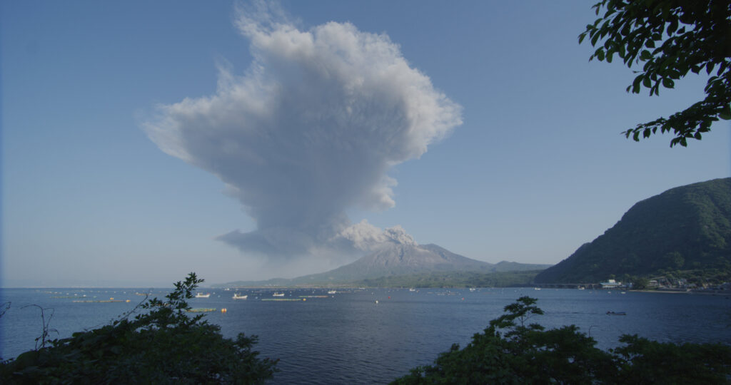
Sakurajima, one of the world’s most active volcanoes, is located in the south of Japan. Scientists are predicting a repeat of the 1914 plinian size eruption within the next 30 years.
Sakurajima, one of the world’s most active volcanoes
Peter Majtan, CTO and Co-Founder at DERYL Group K.K works with NHK, SVO, MLIT and the Kyoto University to create an up-to-date high-resolution 3D model of the volcano for scientists to run various simulations for disaster prevention and response. Additionally, specific areas on the volcano are planned to be mapped in the highest resolution possible on a regular basis to detect any possible ground deformations. We were invited to talk with him:
Peter, what is the significance and impact of the project?
Our 3D model is used to simulate pyroclastic flow, lava-flow and lahar (cement-like mixture of ash and water) flow paths for various locations on the volcano. This will be used to prioritize evacuation, disaster response and management in the initial and secondary stages of an eruption.
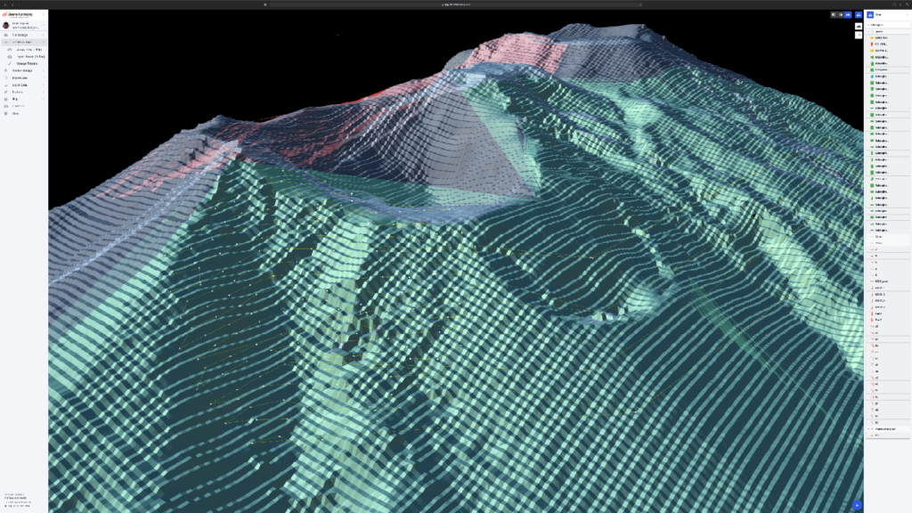
Screenshot of Drone Harmony UAV volcano flight planning
What are the technical challenges that you are facing in this project?
There are quite a few:
Sakurajima is a rather steep volcano and the vast majority of drone mission planning solutions are not terrain-aware and therefore useless to us.
The area within 2km radius around the currently active crater are off-limits due to ongoing daily activity. This, combined with the sheer size (75 km2), steep nature of the volcano, complex terrain with pretty much non-existent road access and the 500m height limit of DJI-based drones – all result in extremely complicated flight planning.
The constant daily activity of the volcano, the outpouring of ash and SO2-rich gas (Sulphur Dioxide, extremely corrosive and deadly) complicates things in terms of both visibility – as our 3D terrain mapping method relies on photogrammetry – as well as the actual danger to the drones and the crew. We need to carefully monitor the wind direction and are forced to change our location during the day, or in many instances completely abandon work for the day.
How long did it take to complete the current stage of the project?
So far we have mapped the south-east half of the volcano – the area of most activity and danger. Due to the technical difficulties mentioned above – it took us over 4 months to achieve this.
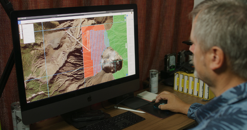
Peter Majtan planning in Drone Harmony Web
How will the data from the mapping be technically used to generate insights?
The scientists are using our 3D terrain model of the volcano to run all possible simulations of the expected Plinian eruption to determine the various paths of flow for pyroclastics clouds, lava and lahar depending on the actual points of eruption. Even with their powerful supercomputers these simulations take a lot of time and it will be almost impossible to run these once the eruption begins and the actual points of breach (new craters) are known.
During a Plinian eruption at first the ash column rises to the sky and it takes at least 30-60 minutes for it to start collapsing under its own weight and start generating the extremely dangerous pyroclastic flows – think Pompeii and Herculaneum. Every minute is crucial. The goal is that the scientists run all the various scenarios in advance, so once the eruption begins and actual locations of the new craters are known – they will be able to quickly determine the likely paths of the pyroclastic flows and therefore be able to prioritize and focus emergency response and evacuation – potentially saving thousands of lives.
Additionally – aside from the computer simulations – our 3D terrain data (in particular the repetitive mapping of the most dangerous areas in the highest possible level of resolution and accuracy) will be used to monitor any ground deformations by comparison with previous data sets. This will help with the prediction of future activity.
Minamidake crater with Kagoshima City in the background
How could Drone Harmony help you resolve some of these challenges?
The terrain-aware mission planning in Drone Harmony was the number one reason why we selected it for our project. This was closely followed by the ability to plan various complicated missions for later offline use. Drone Harmony is also great for managing such a large and complicated site – and the need to repeat many of the missions on regular intervals for years to come. Finally – and certainly not the least – we really appreciate the access to top-level management and engineering at Drone Harmony for personalized support such a complicated project requires and depends on. I am especially excited about a possibility to develop volcano-specific missions that could be useful for similar projects at other active volcanoes around the world.
Screenshot of Drone Harmony volcano drone flight planning
Thank you Peter for these exciting insights into your work and keep up the safe flights!
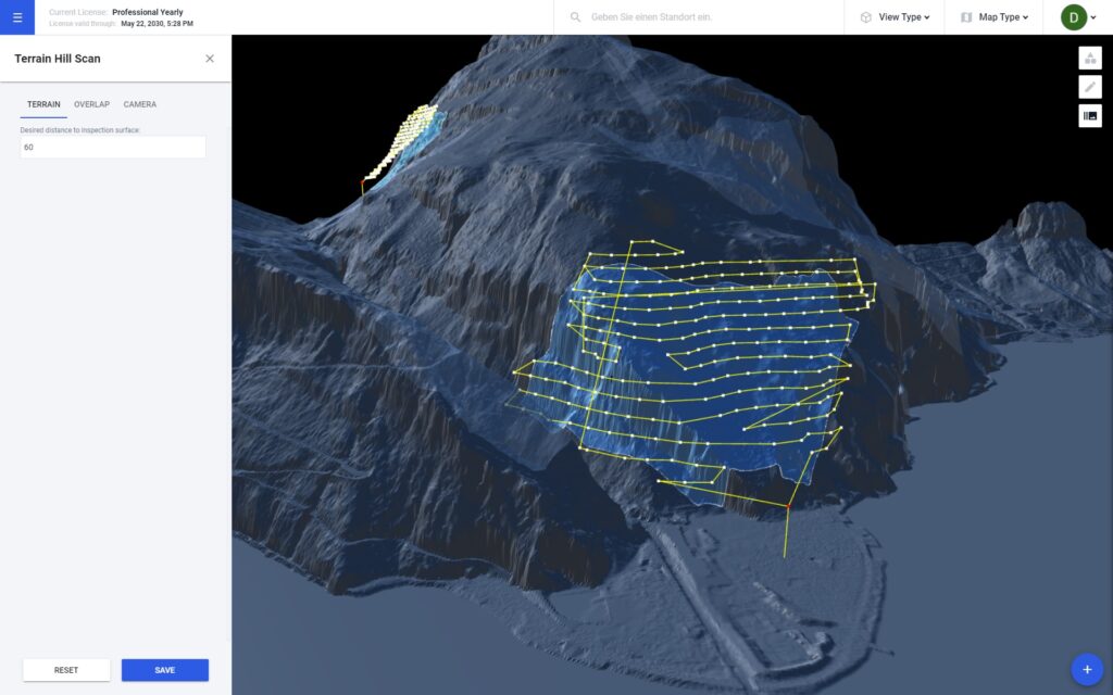
Drone Harmony’s Hill Scan: Mapping Complex and Steep Terrain
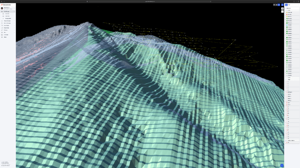
One of the most unique features of Drone Harmony Web is Hill Scan – an automated flight mission that allows you to inspect and map very complex and steep terrain. It is a powerful and very flexible plan that is useful in various use cases including:
1. When the terrain to be inspected is very steep (even vertical), e.g. when it represents cliffs, rock walls, steep hills, or even structures, such as dams. 2. When the terrain profile is very non-uniform, e.g. hills, mountain peaks, canyons, and valleys, or combinations of flat and steep sections of a landscape. 3. When it is important to direct the camera perpendicularly at the terrain surface.
The terrain-aware mission planning in Drone Harmony was the number one reason why we selected it for our project.
Peter Majtan, CTO and Co-Founder at DERYL Group K.K
Planning a Hill Scan Mission in Drone Harmony Web
Industries
Business intelligence derived from drone data is only as good as the data that is used to generate it.
Drone harmony would have to be the best equipped flight planning app I've ever used. It works perfectly for vertical and complex structures, along with a large number of mission types to achieve the best results for your target asset.
Danny Elassad, Chief Remote Pilot,Hoverscape
Drone Harmony is the best Flight Planning Platform I've used to cover the dynamic terrain of our mining business with it's Terrain Following feature.
Muhammad Ilyas, Deputy Manager Mine Planning,Sindh Engro Coal Mining Company (SECMC)
Amazing app, easy to use and powerful. Offers all the things I need for scene inspection of many kinds (towers, antennas, construction sites, private residential zones, etc...). Also good mapping grids and parameters setting.
Jose Benitez, Co-Founder,TucanoRobotics
Excellent application, it is worth going for the paid version. It works perfectly, even with simple drones like DJI Spark.
Luis Eduardo Cuevas Correa, Founder,Lekazo
Obtaining a point cloud of the entire site in a few hours using a drone is a huge benefit to the schedule and the budget.
Jesse Creech, VDC Coordinator,Brasfield & Gorrie
Drone Harmony
proved itself admirably, and we
achieved in automated flight what
would have taken enormous risk
and complexity in manual flight.
Michael Appleyard, CEO,Drone Inspection WA
Setting up our missions in Drone Harmony has been easy thanks to great tutorials and excellent support from the Drone Harmony Team. Thank you!
Dwayne Marx, Founder
With the Drone Harmony application
data acquisition was consistent, the flight
patterns and automation provided
us with consistent high-quality models
for the purposes of tower
inspections.
Stanley du Toit, Solution Architect,The iGlobe Group
Legislative Update On June 18, 2024, the House of Representatives passed the National Defense Authorization Act (NDAA), which includes the “Countering CCP Drones Act.” This bill aims to ban DJI drones by prohibiting their use of FCC communication infrastructure. However, the Senate Armed Services Committee (SASC) has recently released its marked-up version of the 2025...
We’ve added ‘tap focus’, by clicking on any point in a live DJI Dock video feed from your drone, the drone will focus its camera on this designated area. This feature gives users never-before-seen real-time control of their drones, allowing them to pinpoint critical areas with unprecedented precision. In addition, we have also made further...
We’re thrilled to announce a major update that combines all versions of our app into one streamlined platform, providing enhanced convenience and efficiency for both enterprise and professional users. Consolidation of Versions With this update, we have merged all versions of the app into a single comprehensive platform. This consolidation includes: Improved Accessibility Upon opening...