Drone Harmony Power Scanner: Advancing Power Utility Line Inspection
Drone technology is transforming the power utilities industry, enabling more efficient and cost-effective operations for inspecting and maintaining critical infrastructure. One platform that is leading the charge in this space is Drone Harmony Power Scanner, which offers a suite of advanced features designed specifically for line inspection.
From App Launch to Drone Takeoff: A Timeframe of 1-2 Minutes
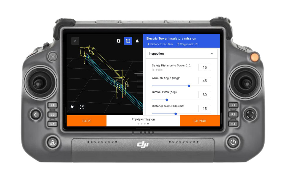
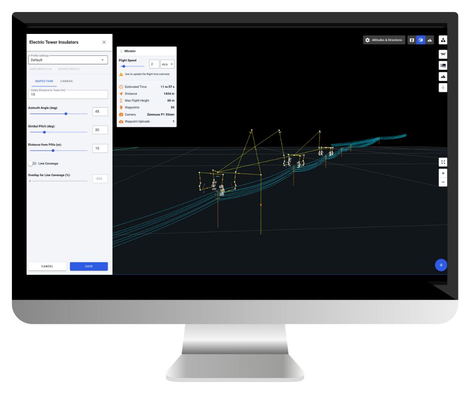
At the heart of the platform is a visual Full-3D interface that guides users through every step of the planning process. The platform generates ready-to-fly missions that are optimized for specific types of powerlines, masts, and transmission towers, ensuring that each mission is tailored to the unique requirements of the task at hand.
Achieving Unprecedented Flight Accuracy and Detailed Image Data
One of the standout features of Drone Harmony is its terrain-awareness capabilities, which leverage custom terrain data to optimize flight paths and ensure accurate data collection in challenging environments. Additionally, the platform supports the automated import of key file formats used in the power utilities industry, including PLS CADD, DXF, and las/laz.
Efficient and Customizable Mission Planning
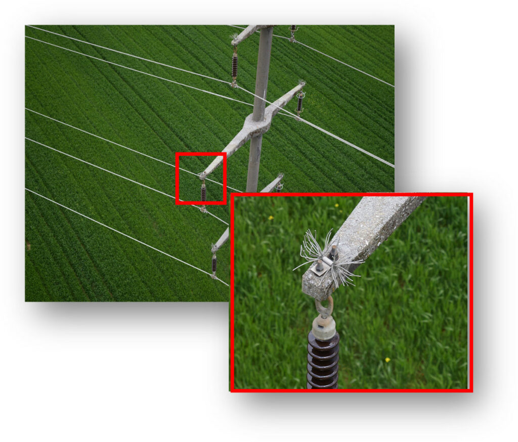
Drone Harmony also supports a range of professional DJI drones and custom payloads, such as the Phase One P3, which can be used to capture high-resolution images and videos for detailed analysis. The platform’s hybrid flight modes enable zoom and manual adjustments for visual inspection to be incorporated into an automated workflow, further enhancing the efficiency and effectiveness of inspections.
Overall, Drone Harmony is a powerful tool for power utilities professionals seeking to enhance their inspection operations. Its specialized capabilities and intuitive interface make it ideal for conducting safe, efficient, and precise critical infrastructure inspections.
We’d love to hear from you! If you have any questions or want to learn more about the game-changing Drone Harmony Power Scanner and how it can transform your power utility operations, please don’t hesitate to contact us. Our expert team is always ready to assist you and provide the best possible solutions to meet your needs.
Industries
Business intelligence derived from drone data is only as good as the data that is used to generate it.
Drone harmony would have to be the best equipped flight planning app I've ever used. It works perfectly for vertical and complex structures, along with a large number of mission types to achieve the best results for your target asset.
Danny Elassad, Chief Remote Pilot,Hoverscape
Drone Harmony is the best Flight Planning Platform I've used to cover the dynamic terrain of our mining business with it's Terrain Following feature.
Muhammad Ilyas, Deputy Manager Mine Planning,Sindh Engro Coal Mining Company (SECMC)
Amazing app, easy to use and powerful. Offers all the things I need for scene inspection of many kinds (towers, antennas, construction sites, private residential zones, etc...). Also good mapping grids and parameters setting.
Jose Benitez, Co-Founder,TucanoRobotics
Excellent application, it is worth going for the paid version. It works perfectly, even with simple drones like DJI Spark.
Luis Eduardo Cuevas Correa, Founder,Lekazo
Obtaining a point cloud of the entire site in a few hours using a drone is a huge benefit to the schedule and the budget.
Jesse Creech, VDC Coordinator,Brasfield & Gorrie
Drone Harmony
proved itself admirably, and we
achieved in automated flight what
would have taken enormous risk
and complexity in manual flight.
Michael Appleyard, CEO,Drone Inspection WA
Setting up our missions in Drone Harmony has been easy thanks to great tutorials and excellent support from the Drone Harmony Team. Thank you!
Dwayne Marx, Founder
With the Drone Harmony application
data acquisition was consistent, the flight
patterns and automation provided
us with consistent high-quality models
for the purposes of tower
inspections.
Stanley du Toit, Solution Architect,The iGlobe Group
Legislative Update On June 18, 2024, the House of Representatives passed the National Defense Authorization Act (NDAA), which includes the “Countering CCP Drones Act.” This bill aims to ban DJI drones by prohibiting their use of FCC communication infrastructure. However, the Senate Armed Services Committee (SASC) has recently released its marked-up version of the 2025...
We’ve added ‘tap focus’, by clicking on any point in a live DJI Dock video feed from your drone, the drone will focus its camera on this designated area. This feature gives users never-before-seen real-time control of their drones, allowing them to pinpoint critical areas with unprecedented precision. In addition, we have also made further...
We’re thrilled to announce a major update that combines all versions of our app into one streamlined platform, providing enhanced convenience and efficiency for both enterprise and professional users. Consolidation of Versions With this update, we have merged all versions of the app into a single comprehensive platform. This consolidation includes: Improved Accessibility Upon opening...