Drone Harmony supports Parrot ANAFI Ai for complex missions

The solution allows complex topography and vertical structure mapping missions with the professional-grade micro-drone designed for photogrammetry.


This partnership combines Parrot’s top-of-the-line 4G connected professional drones with Drone Harmony’s Software to provide inspection and mapping professionals with automated data acquisition capabilities in the most challenging scenarios. The duo guarantees high-quality and safe reproducible data collection.

Parrot ANAFI Ai’s 48 MP images captured at 1 frame per second provide the best photogrammetry solution of its category: mapping quicker for the same data quality/mapping larger surface for the same mission duration.

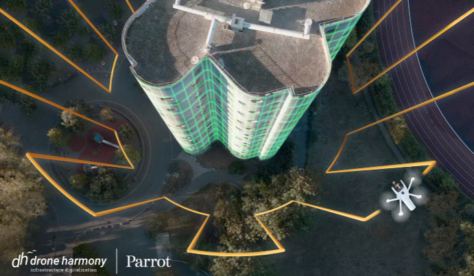
Leveraging Parrot ANAFI Ai’s outstanding photogrammetry characteristics, Drone Harmony’s Application allows inspection professionals to eliminate errors by optimizing the drone position to capture the most accurate data. The flight planner considers the ground level for large-scale topography missions. Drone Harmony also allows flight planning for building facades mapping and inspection of industrial infrastructure. Coupled with the ANAFI Ai’s 4G connectivity, the solution is particularly acute for mapping in interferences-ridden urban areas where Wi-Fi might be very challenging.

The data captured with the Parrot ANAFI Ai and Drone Harmony Application can then be used by professionals to rapidly survey and/or generate precise 2D and 3D maps of buildings, telecommunications assets, power lines, industrial sites, bridges, railways, mines, mountains road, quarries, forests, cliffs

Once a flight plan is created in the Drone Harmony web application, it can be shared through Parrot FreeFlight 7, the App designed to control Parrot ANAFI Ai. The flight plan then appears on the usual App interface. It can be run as any other FreeFlight flight plan mission.

Last but not least, this compatibility offers users privacy by design. Parrot does not monitor professionals and their businesses. Parrot ANAFI Ai natively takes off anywhere. Parrot and Drone Harmony are GDPR compliant. Flight logs and all sensitive data collected by Parrot ANAFI Ai can be stored locally, on Parrot’s GDPR-compliant servers based in Europe and its users can choose not to share their information.

Website Parrot

Industries

Business intelligence derived from drone data is only as good as the data that is used to generate it.

What our customers say

Drone harmony would have to be the best equipped flight planning app I've ever used. It works perfectly for vertical and complex structures, along with a large number of mission types to achieve the best results for your target asset.

Danny Elassad, Chief Remote Pilot, Hoverscape

Drone Harmony is the best Flight Planning Platform I've used to cover the dynamic terrain of our mining business with it's Terrain Following feature.

Muhammad Ilyas, Deputy Manager Mine Planning, Sindh Engro Coal Mining Company (SECMC)

Amazing app, easy to use and powerful. Offers all the things I need for scene inspection of many kinds (towers, antennas, construction sites, private residential zones, etc...). Also good mapping grids and parameters setting.

Jose Benitez, Co-Founder, TucanoRobotics

Excellent application, it is worth going for the paid version. It works perfectly, even with simple drones like DJI Spark.

Luis Eduardo Cuevas Correa, Founder, Lekazo

Obtaining a point cloud of the entire site in a few hours using a drone is a huge benefit to the schedule and the budget.

Jesse Creech, VDC Coordinator, Brasfield & Gorrie

Drone Harmony proved itself admirably, and we achieved in automated flight what would have taken enormous risk and complexity in manual flight.

Michael Appleyard, CEO, Drone Inspection WA

Setting up our missions in Drone Harmony has been easy thanks to great tutorials and excellent support from the Drone Harmony Team. Thank you!

Dwayne Marx, Founder

With the Drone Harmony application data acquisition was consistent, the flight patterns and automation provided us with consistent high-quality models for the purposes of tower inspections.

Stanley du Toit, Solution Architect, The iGlobe Group

Partners

Become a partner Learn more

Latest company updates

Update: Senate Committee Omits DJI Drone Ban from NDAA

Legislative Update On June 18, 2024, the House of Representatives passed the National Defense Authorization Act (NDAA), which includes the “Countering CCP Drones Act.” This bill aims to ban DJI drones by prohibiting their use of FCC communication infrastructure. However, the Senate Armed Services Committee (SASC) has recently released its marked-up version of the 2025...

Continue reading

“Tap To Focus” In The Live Dock Video Feed

We’ve added ‘tap focus’, by clicking on any point in a live DJI Dock video feed from your drone, the drone will focus its camera on this designated area. This feature gives users never-before-seen real-time control of their drones, allowing them to pinpoint critical areas with unprecedented precision. In addition, we have also made further...

Continue reading

Major Update: Consolidating Versions for Enhanced Efficiency

We’re thrilled to announce a major update that combines all versions of our app into one streamlined platform, providing enhanced convenience and efficiency for both enterprise and professional users. Consolidation of Versions With this update, we have merged all versions of the app into a single comprehensive platform. This consolidation includes: Improved Accessibility Upon opening...

Continue reading